Domsten geodata
Domsten (Skåne) is a populated place; located in Sweden in Europe/Stockholm (GMT+2) time zone. With population of 625 people, there are 1150 cities with bigger population in this country. Compared to other cities in Sweden, 90.2% of cities are located further ↑North; 87.2% of cities are located further →East and 91.5% of cities have higher elevation than Domsten. Note1


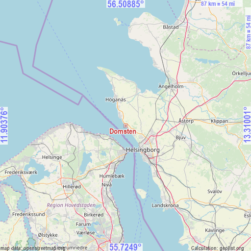
Domsten GPS coordinates[2]
56° 7' 7.932" North, 12° 36' 24.768" East
| Map corner | latitude | longitude |
|---|---|---|
| Upper-left | 56.50885°, | 11.90376° |
| Center: | 56.11887°, | 12.60688° |
| Lower-right: | 55.7249°, | 13.31001° |
| Map W x H: | 87.2×87.2 km | = 54.2×54.2mi |
| max Lat: | 67.85572° ⇑90.2% North |
| Domsten: | 56.11887° |
| min Lat: | ⇓9.8% South 55.34337° |
| min Long | Domsten | max Long |
| 11.1712° | 12.60688° | 24.13676° |
| W 12.8%⇐ | ⇒87.2% E |
Elevation
Elevation of Domsten is 8 m = 26 ft, and this is 74.6 m = 245 ft below average elevation for this country.
| Max E: |
663 m = 2175 ft | 91.5% |
| Avg. | 82.6 m = 271 ft | |
| Domsten | 8 m = 26 ft | |
Min E: |
-1 m = -3 ft | 8.5% |
See also: Sweden elevation on elevation.city.
Geographical zone
Domsten is located in North temperate zone (between Tropic of Cancer and the Arctic Circle). Distance of this North polar circle is 1161.3 km =721.6 mi to North.| Distance of | km | miles | from Domsten |
|---|---|---|---|
| North Pole | 3767.2 | 2340.8 | to North |
| Arctic Circle | 1161.3 | 721.6 | to North |
| Tropic Cancer | 3633.9 | 2258 | to South |
| Equator | 6239.8 | 3877.2 | to South |


Nearby cities:
15 places around Domsten: (largest is in red/bold)
• Allerum
5.4 km =3.4 mi,  88°
88°
• Arild
17.5 km =10.9 mi,  353°
353°
• Bårslöv
17.4 km =10.8 mi,  134°
134°
• Hasslarp
13.1 km =8.1 mi,  82°
82°
• Helsingborg
9.7 km =6 mi,  145°
145°
• Hittarp
2.7 km =1.7 mi,  141°
141°
• Hyllinge
15.2 km =9.4 mi,  97°
97°
• Höganäs
9.5 km =5.9 mi,  341°
341°
• Jonstorp
13.4 km =8.3 mi,  17°
17°
• Kattarp
11.1 km =6.9 mi, 77°
• Mörarp
18.3 km =11.4 mi,  111°
111°
• Påarp
16.1 km =10 mi, 126°
• Strövelstorp
15.5 km =9.6 mi,  68°
68°
• Viken
4.1 km =2.5 mi,  330°
330°
• Ödåkra
8.9 km =5.5 mi, 100°
Sources, notices
• [Note1] Compared only with cities in Sweden existing in our database
• [Src1] Map data: © OpenStreetMap contributors (CC-BY-SA)
• [Src2] Other city data from geonames.org with taken over terms of usage.
• [Src3] Geographical zone / Annual Mean Temperature by Robert A. Rohde @ Wikipedia
