Årsunda geodata
Årsunda (Gävleborg) is a populated place; located in Sweden in Europe/Stockholm (GMT+2) time zone. With population of 1,012 people, there are 809 cities with bigger population in this country. Compared to other cities in Sweden, 78.7% of cities are located further ↓South; 71.7% of cities are located further ←West and 52.1% of cities have lower elevation than Årsunda. Note1


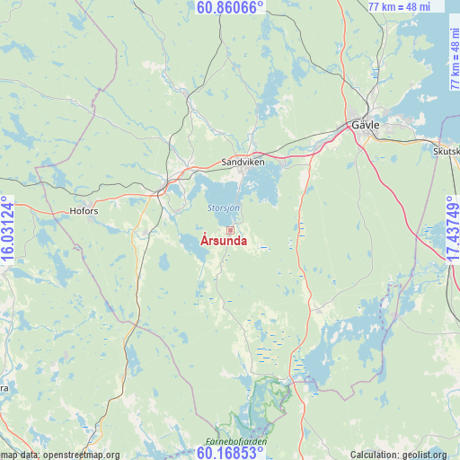
Årsunda GPS coordinates[2]
60° 30' 59.184" North, 16° 44' 3.696" East
| Map corner | latitude | longitude |
|---|---|---|
| Upper-left | 60.86066°, | 16.03124° |
| Center: | 60.51644°, | 16.73436° |
| Lower-right: | 60.16853°, | 17.43749° |
| Map W x H: | 77×77 km | = 47.8×47.8mi |
| max Lat: | 67.85572° ⇑21.3% North |
| Årsunda: | 60.51644° |
| min Lat: | ⇓78.7% South 55.34337° |
| min Long | Årsunda | max Long |
| 11.1712° | 16.73436° | 24.13676° |
| W 71.7%⇐ | ⇒28.3% E |
Elevation
Elevation of Årsunda is 54 m = 177 ft, and this is 28.6 m = 94 ft below average elevation for this country.
| Max E: |
663 m = 2175 ft | 47.9% |
| Avg. | 82.6 m = 271 ft | |
| Årsunda | 54 m = 177 ft | |
Min E: |
-1 m = -3 ft | 52.1% |
See also: Sweden elevation on elevation.city.
Geographical zone
Årsunda is located in North temperate zone (between Tropic of Cancer and the Arctic Circle). Distance of this North polar circle is 672.4 km =417.8 mi to North.| Distance of | km | miles | from Årsunda |
|---|---|---|---|
| North Pole | 3278.3 | 2037 | to North |
| Arctic Circle | 672.4 | 417.8 | to North |
| Tropic Cancer | 4122.9 | 2561.9 | to South |
| Equator | 6728.8 | 4181.1 | to South |


Nearby cities:
15 places around Årsunda: (largest is in red/bold)
• Forsbacka
13.8 km =8.6 mi,  36°
36°
• Forsby
31.1 km =19.3 mi, 44°
• Gävle
28.3 km =17.6 mi,  51°
51°
• Hammarby
9.5 km =5.9 mi,  288°
288°
• Hedesunda
19.5 km =12.1 mi,  131°
131°
• Hofors
24.7 km =15.3 mi,  277°
277°
• Horndal
29.7 km =18.5 mi,  215°
215°
• Järbo
23.4 km =14.5 mi,  341°
341°
• Kungsgården
11.3 km =7 mi,  325°
325°
• Sandviken
11.3 km =7 mi,  9°
9°
• Storvik
13.3 km =8.3 mi,  304°
304°
• Torsåker
14.4 km =8.9 mi,  267°
267°
• Valbo
22.1 km =13.7 mi, 47°
• Åshammar
16.4 km =10.2 mi,  324°
324°
• Överhärde
16.9 km =10.5 mi, 48°
Sources, notices
• [Note1] Compared only with cities in Sweden existing in our database
• [Src1] Map data: © OpenStreetMap contributors (CC-BY-SA)
• [Src2] Other city data from geonames.org with taken over terms of usage.
• [Src3] Geographical zone / Annual Mean Temperature by Robert A. Rohde @ Wikipedia
