Borgholm geodata
Borgholm (Kalmar) is a seat of a second-order administrative division; located in Sweden in Europe/Stockholm (GMT+2) time zone. With population of 4,344 people, there are 311 cities with bigger population in this country. Compared to other cities in Sweden, 79% of cities are located further ↑North; 71.1% of cities are located further ←West and 93.9% of cities have higher elevation than Borgholm. Note1


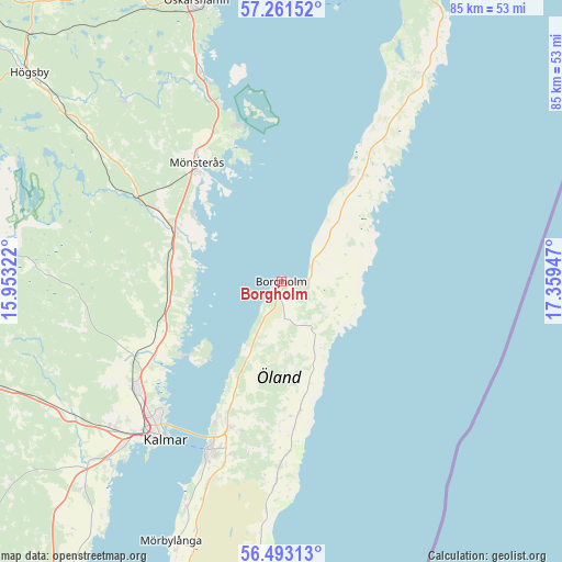
Borgholm GPS coordinates[2]
56° 52' 45.48" North, 16° 39' 22.824" East
| Map corner | latitude | longitude |
|---|---|---|
| Upper-left | 57.26152°, | 15.95322° |
| Center: | 56.8793°, | 16.65634° |
| Lower-right: | 56.49313°, | 17.35947° |
| Map W x H: | 85.4×85.4 km | = 53.1×53.1mi |
| max Lat: | 67.85572° ⇑79% North |
| Borgholm: | 56.8793° |
| min Lat: | ⇓21% South 55.34337° |
| min Long | Borgholm | max Long |
| 11.1712° | 16.65634° | 24.13676° |
| W 71.1%⇐ | ⇒28.9% E |
Elevation
Elevation of Borgholm is 6 m = 20 ft, and this is 76.6 m = 251 ft below average elevation for this country.
| Max E: |
663 m = 2175 ft | 93.9% |
| Avg. | 82.6 m = 271 ft | |
| Borgholm | 6 m = 20 ft | |
Min E: |
-1 m = -3 ft | 6.1% |
See also: Sweden elevation on elevation.city.
Geographical zone
Borgholm is located in North temperate zone (between Tropic of Cancer and the Arctic Circle). Distance of this North polar circle is 1076.8 km =669.1 mi to North.| Distance of | km | miles | from Borgholm |
|---|---|---|---|
| North Pole | 3682.7 | 2288.3 | to North |
| Arctic Circle | 1076.8 | 669.1 | to North |
| Tropic Cancer | 3718.5 | 2310.6 | to South |
| Equator | 6324.4 | 3929.8 | to South |


Nearby cities:
15 places around Borgholm: (largest is in red/bold)
• Algutsrum
23.2 km =14.4 mi,  199°
199°
• Blomstermåla
22.8 km =14.2 mi,  300°
300°
• Fliseryd
36.8 km =22.9 mi,  320°
320°
• Färjestaden
28 km =17.4 mi, 204°
• Kalmar
30.1 km =18.7 mi,  216°
216°
• Lindsdal
27.1 km =16.8 mi,  233°
233°
• Mönsterås
22.1 km =13.7 mi, 324°
• Påskallavik
34.3 km =21.3 mi,  338°
338°
• Rinkabyholm
34.9 km =21.7 mi, 222°
• Rockneby
20.5 km =12.7 mi,  245°
245°
• Skogsby
28.2 km =17.5 mi, 196°
• Smedby
34 km =21.1 mi, 227°
• Södra Sandby
34.8 km =21.6 mi,  183°
183°
• Timmernabben
16.7 km =10.4 mi,  305°
305°
• Ålem
18.3 km =11.4 mi, 295°
Sources, notices
• [Note1] Compared only with cities in Sweden existing in our database
• [Src1] Map data: © OpenStreetMap contributors (CC-BY-SA)
• [Src2] Other city data from geonames.org with taken over terms of usage.
• [Src3] Geographical zone / Annual Mean Temperature by Robert A. Rohde @ Wikipedia
