Mönsterås geodata
Mönsterås (Kalmar) is a seat of a second-order administrative division; located in Sweden in Europe/Stockholm (GMT+2) time zone. With population of 4,998 people, there are 273 cities with bigger population in this country. Compared to other cities in Sweden, 77.5% of cities are located further ↑North; 67.5% of cities are located further ←West and 91.5% of cities have higher elevation than Mönsterås. Note1


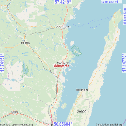
Mönsterås GPS coordinates[2]
57° 2' 28.824" North, 16° 26' 40.668" East
| Map corner | latitude | longitude |
|---|---|---|
| Upper-left | 57.4219°, | 15.74151° |
| Center: | 57.04134°, | 16.44463° |
| Lower-right: | 56.65684°, | 17.14776° |
| Map W x H: | 85.1×85.1 km | = 52.9×52.9mi |
| max Lat: | 67.85572° ⇑77.5% North |
| Mönsterås: | 57.04134° |
| min Lat: | ⇓22.5% South 55.34337° |
| min Long | Mönsterås | max Long |
| 11.1712° | 16.44463° | 24.13676° |
| W 67.5%⇐ | ⇒32.5% E |
Elevation
Elevation of Mönsterås is 8 m = 26 ft, and this is 74.6 m = 245 ft below average elevation for this country.
| Max E: |
663 m = 2175 ft | 91.5% |
| Avg. | 82.6 m = 271 ft | |
| Mönsterås | 8 m = 26 ft | |
Min E: |
-1 m = -3 ft | 8.5% |
See also: Sweden elevation on elevation.city.
Geographical zone
Mönsterås is located in North temperate zone (between Tropic of Cancer and the Arctic Circle). Distance of this North polar circle is 1058.8 km =657.9 mi to North.| Distance of | km | miles | from Mönsterås |
|---|---|---|---|
| North Pole | 3664.7 | 2277.1 | to North |
| Arctic Circle | 1058.8 | 657.9 | to North |
| Tropic Cancer | 3736.5 | 2321.8 | to South |
| Equator | 6342.4 | 3941 | to South |


Nearby cities:
15 places around Mönsterås: (largest is in red/bold)
• Algutsrum
40.2 km =25 mi,  172°
172°
• Berga
31.6 km =19.6 mi,  308°
308°
• Blomstermåla
9.3 km =5.8 mi,  226°
226°
• Borgholm
22.1 km =13.7 mi,  144°
144°
• Figeholm
36.7 km =22.8 mi,  9°
9°
• Fliseryd
14.8 km =9.2 mi, 313°
• Högsby
28.8 km =17.9 mi,  298°
298°
• Lindsdal
35.4 km =22 mi,  194°
194°
• Löttorp
35.4 km =22 mi,  66°
66°
• Oskarshamn
24.8 km =15.4 mi,  0°
0°
• Påskallavik
13.9 km =8.6 mi, 1°
• Rockneby
27.2 km =16.9 mi, 192°
• Ruda
21.3 km =13.2 mi,  290°
290°
• Timmernabben
8.3 km =5.2 mi,  184°
184°
• Ålem
10.8 km =6.7 mi,  200°
200°
Sources, notices
• [Note1] Compared only with cities in Sweden existing in our database
• [Src1] Map data: © OpenStreetMap contributors (CC-BY-SA)
• [Src2] Other city data from geonames.org with taken over terms of usage.
• [Src3] Geographical zone / Annual Mean Temperature by Robert A. Rohde @ Wikipedia
