Bollmora geodata
Bollmora (Stockholm) is a seat of a second-order administrative division; located in Sweden in Europe/Stockholm (GMT+2) time zone. In our database, there are 1312 cities with bigger population. Compared to other cities in Sweden, 57.9% of cities are located further ↓South; 88.4% of cities are located further ←West and 56% of cities have higher elevation than Bollmora. Note1


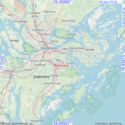
Bollmora GPS coordinates[2]
59° 14' 31.056" North, 18° 13' 39.432" East
| Map corner | latitude | longitude |
|---|---|---|
| Upper-left | 59.59966°, | 17.5245° |
| Center: | 59.24196°, | 18.22762° |
| Lower-right: | 58.88047°, | 18.93075° |
| Map W x H: | 80×80 km | = 49.7×49.7mi |
| max Lat: | 67.85572° ⇑42.1% North |
| Bollmora: | 59.24196° |
| min Lat: | ⇓57.9% South 55.34337° |
| min Long | Bollmora | max Long |
| 11.1712° | 18.22762° | 24.13676° |
| W 88.4%⇐ | ⇒11.6% E |
Elevation
Elevation of Bollmora is 41 m = 135 ft, and this is 41.6 m = 136 ft below average elevation for this country.
| Max E: |
663 m = 2175 ft | 56% |
| Avg. | 82.6 m = 271 ft | |
| Bollmora | 41 m = 135 ft | |
Min E: |
-1 m = -3 ft | 44% |
See also: Sweden elevation on elevation.city.
Geographical zone
Bollmora is located in North temperate zone (between Tropic of Cancer and the Arctic Circle). Distance of this North polar circle is 814.1 km =505.9 mi to North.| Distance of | km | miles | from Bollmora |
|---|---|---|---|
| North Pole | 3420 | 2125.1 | to North |
| Arctic Circle | 814.1 | 505.9 | to North |
| Tropic Cancer | 3981.2 | 2473.8 | to South |
| Equator | 6587.1 | 4093 | to South |


Nearby cities:
15 places around Bollmora: (largest is in red/bold)
• Boo
10.6 km =6.6 mi,  17°
17°
• Brevik
9.3 km =5.8 mi,  107°
107°
• Brevik
12.1 km =7.5 mi,  352°
352°
• Fisksätra
5.7 km =3.5 mi, 15°
• Handen
9.7 km =6 mi,  211°
211°
• Haninge
9.5 km =5.9 mi, 209°
• Hästhagen
7.8 km =4.8 mi,  325°
325°
• Jordbro
12 km =7.5 mi, 211°
• Nacka
8.4 km =5.2 mi, 334°
• Raksta
4.6 km =2.9 mi,  119°
119°
• Saltsjöbaden
6.2 km =3.9 mi,  41°
41°
• Södermalm
11.7 km =7.3 mi,  312°
312°
• Vidja
10.3 km =6.4 mi,  243°
243°
• Älta
3.7 km =2.3 mi,  317°
317°
• Årsta
11.8 km =7.3 mi,  301°
301°
Sources, notices
• [Note1] Compared only with cities in Sweden existing in our database
• [Src1] Map data: © OpenStreetMap contributors (CC-BY-SA)
• [Src2] Other city data from geonames.org with taken over terms of usage.
• [Src3] Geographical zone / Annual Mean Temperature by Robert A. Rohde @ Wikipedia
