Jordbro geodata
Jordbro (Stockholm) is a populated place; located in Sweden in Europe/Stockholm (GMT+2) time zone. With population of 10,757 people, there are 141 cities with bigger population in this country. Compared to other cities in Sweden, 55.8% of cities are located further ↓South; 87.4% of cities are located further ←West and 50.9% of cities have lower elevation than Jordbro. Note1


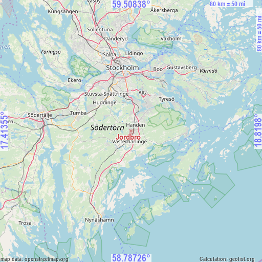
Jordbro GPS coordinates[2]
59° 8' 58.992" North, 18° 7' 0.012" East
| Map corner | latitude | longitude |
|---|---|---|
| Upper-left | 59.50838°, | 17.41355° |
| Center: | 59.14972°, | 18.11667° |
| Lower-right: | 58.78726°, | 18.8198° |
| Map W x H: | 80.2×80.2 km | = 49.8×49.8mi |
| max Lat: | 67.85572° ⇑44.2% North |
| Jordbro: | 59.14972° |
| min Lat: | ⇓55.8% South 55.34337° |
| min Long | Jordbro | max Long |
| 11.1712° | 18.11667° | 24.13676° |
| W 87.4%⇐ | ⇒12.6% E |
Elevation
Elevation of Jordbro is 52 m = 171 ft, and this is 30.6 m = 100 ft below average elevation for this country.
| Max E: |
663 m = 2175 ft | 49.1% |
| Avg. | 82.6 m = 271 ft | |
| Jordbro | 52 m = 171 ft | |
Min E: |
-1 m = -3 ft | 50.9% |
See also: Sweden elevation on elevation.city.
Geographical zone
Jordbro is located in North temperate zone (between Tropic of Cancer and the Arctic Circle). Distance of this North polar circle is 824.3 km =512.2 mi to North.| Distance of | km | miles | from Jordbro |
|---|---|---|---|
| North Pole | 3430.2 | 2131.4 | to North |
| Arctic Circle | 824.3 | 512.2 | to North |
| Tropic Cancer | 3970.9 | 2467.4 | to South |
| Equator | 6576.8 | 4086.6 | to South |


Nearby cities:
15 places around Jordbro: (largest is in red/bold)
• Bollmora
12 km =7.5 mi,  31°
31°
• Brevik
16.9 km =10.5 mi,  63°
63°
• Dalarö
16.6 km =10.3 mi,  96°
96°
• Grödby
17.3 km =10.7 mi,  230°
230°
• Handen
2.4 km =1.5 mi, 30°
• Haninge
2.6 km =1.6 mi,  38°
38°
• Huddinge
12.4 km =7.7 mi,  321°
321°
• Hästhagen
16.8 km =10.4 mi,  6°
6°
• Raksta
13.1 km =8.1 mi,  52°
52°
• Segersäng
17.1 km =10.6 mi,  217°
217°
• Tullinge
13.6 km =8.5 mi,  294°
294°
• Tumba
17 km =10.6 mi, 288°
• Vidja
6.3 km =3.9 mi,  332°
332°
• Älta
13.5 km =8.4 mi,  16°
16°
• Årsta
16.9 km =10.5 mi,  347°
347°
Sources, notices
• [Note1] Compared only with cities in Sweden existing in our database
• [Src1] Map data: © OpenStreetMap contributors (CC-BY-SA)
• [Src2] Other city data from geonames.org with taken over terms of usage.
• [Src3] Geographical zone / Annual Mean Temperature by Robert A. Rohde @ Wikipedia
