Raksta geodata
Raksta (Stockholm) is a populated place; located in Sweden in Europe/Stockholm (GMT+2) time zone. With population of 629 people, there are 1148 cities with bigger population in this country. Compared to other cities in Sweden, 57.5% of cities are located further ↓South; 89% of cities are located further ←West and 50.2% of cities have higher elevation than Raksta. Note1
Administrative division(s):
- Level 1: Stockholm
- Level 2: Tyresö Kommun
- Level 3: Tyresö
- Level 4: Tyresö socken


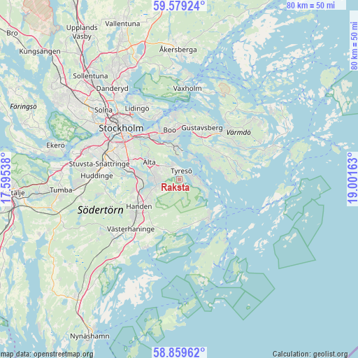
Raksta GPS coordinates[2]
59° 13' 16.788" North, 18° 17' 54.6" East
| Map corner | latitude | longitude |
|---|---|---|
| Upper-left | 59.57924°, | 17.59538° |
| Center: | 59.22133°, | 18.2985° |
| Lower-right: | 58.85962°, | 19.00163° |
| Map W x H: | 80×80 km | = 49.7×49.7mi |
| max Lat: | 67.85572° ⇑42.5% North |
| Raksta: | 59.22133° |
| min Lat: | ⇓57.5% South 55.34337° |
| min Long | Raksta | max Long |
| 11.1712° | 18.2985° | 24.13676° |
| W 89%⇐ | ⇒11% E |
Elevation
Elevation of Raksta is 50 m = 164 ft, and this is 32.6 m = 107 ft below average elevation for this country.
| Max E: |
663 m = 2175 ft | 50.2% |
| Avg. | 82.6 m = 271 ft | |
| Raksta | 50 m = 164 ft | |
Min E: |
-1 m = -3 ft | 49.8% |
See also: Sweden elevation on elevation.city.
Geographical zone
Raksta is located in North temperate zone (between Tropic of Cancer and the Arctic Circle). Distance of this North polar circle is 816.4 km =507.3 mi to North.| Distance of | km | miles | from Raksta |
|---|---|---|---|
| North Pole | 3422.3 | 2126.5 | to North |
| Arctic Circle | 816.4 | 507.3 | to North |
| Tropic Cancer | 3978.9 | 2472.4 | to South |
| Equator | 6584.8 | 4091.6 | to South |


Nearby cities:
15 places around Raksta: (largest is in red/bold)
• Bollmora
4.6 km =2.9 mi,  299°
299°
• Boo
12.5 km =7.8 mi,  356°
356°
• Brevik
4.9 km =3 mi,  96°
96°
• Brunn
9.9 km =6.2 mi,  48°
48°
• Dalarö
11.6 km =7.2 mi,  147°
147°
• Fisksätra
8.2 km =5.1 mi,  342°
342°
• Gustavsberg
12.8 km =8 mi,  23°
23°
• Handen
10.9 km =6.8 mi,  237°
237°
• Haninge
10.6 km =6.6 mi, 235°
• Hästhagen
12.2 km =7.6 mi,  316°
316°
• Jordbro
13.1 km =8.1 mi,  232°
232°
• Långvik
12.7 km =7.9 mi,  77°
77°
• Nacka
12.5 km =7.8 mi, 322°
• Saltsjöbaden
6.9 km =4.3 mi,  0°
0°
• Älta
8.3 km =5.2 mi,  307°
307°
Sources, notices
• [Note1] Compared only with cities in Sweden existing in our database
• [Src1] Map data: © OpenStreetMap contributors (CC-BY-SA)
• [Src2] Other city data from geonames.org with taken over terms of usage.
• [Src3] Geographical zone / Annual Mean Temperature by Robert A. Rohde @ Wikipedia
