Åhus geodata
Åhus (Skåne) is a populated place; located in Sweden in Europe/Stockholm (GMT+2) time zone. With population of 9,840 people, there are 154 cities with bigger population in this country. Compared to other cities in Sweden, 93.7% of cities are located further ↑North; 59.6% of cities are located further →East and 99.8% of cities have higher elevation than Åhus. Note1


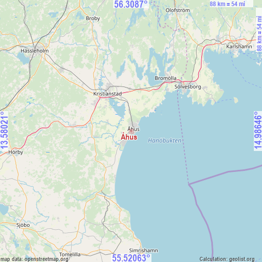
Åhus GPS coordinates[2]
55° 55' 0.012" North, 14° 16' 59.988" East
| Map corner | latitude | longitude |
|---|---|---|
| Upper-left | 56.3087°, | 13.58021° |
| Center: | 55.91667°, | 14.28333° |
| Lower-right: | 55.52063°, | 14.98646° |
| Map W x H: | 87.6×87.6 km | = 54.4×54.4mi |
| max Lat: | 67.85572° ⇑93.7% North |
| Åhus: | 55.91667° |
| min Lat: | ⇓6.3% South 55.34337° |
| min Long | Åhus | max Long |
| 11.1712° | 14.28333° | 24.13676° |
| W 40.4%⇐ | ⇒59.6% E |
Elevation
Elevation of Åhus is 1 m = 3 ft, and this is 81.6 m = 268 ft below average elevation for this country.
| Max E: |
663 m = 2175 ft | 99.8% |
| Avg. | 82.6 m = 271 ft | |
| Åhus | 1 m = 3 ft | |
Min E: |
-1 m = -3 ft | 0.2% |
See also: Sweden elevation on elevation.city.
Geographical zone
Åhus is located in North temperate zone (between Tropic of Cancer and the Arctic Circle). Distance of this North polar circle is 1183.8 km =735.6 mi to North.| Distance of | km | miles | from Åhus |
|---|---|---|---|
| North Pole | 3789.7 | 2354.8 | to North |
| Arctic Circle | 1183.8 | 735.6 | to North |
| Tropic Cancer | 3611.4 | 2244 | to South |
| Equator | 6217.4 | 3863.3 | to South |


Nearby cities:
15 places around Åhus: (largest is in red/bold)
• Bromölla
21.1 km =13.1 mi,  33°
33°
• Degeberga
15.5 km =9.6 mi,  233°
233°
• Everöd
11.6 km =7.2 mi,  260°
260°
• Fjälkinge
14.1 km =8.8 mi,  358°
358°
• Färlöv
20.8 km =12.9 mi,  323°
323°
• Gualöv
17 km =10.6 mi, 29°
• Gärds Köpinge
8.5 km =5.3 mi,  282°
282°
• Hammar
11.9 km =7.4 mi,  339°
339°
• Hammarslund
12.6 km =7.8 mi,  333°
333°
• Kristianstad
15.1 km =9.4 mi, 327°
• Norra Åsum
11.1 km =6.9 mi,  311°
311°
• Rinkaby
7.5 km =4.7 mi,  352°
352°
• Tollarp
18.8 km =11.7 mi, 275°
• Yngsjö
4.7 km =2.9 mi,  212°
212°
• Önnestad
22.6 km =14 mi, 313°
Sources, notices
• [Note1] Compared only with cities in Sweden existing in our database
• [Src1] Map data: © OpenStreetMap contributors (CC-BY-SA)
• [Src2] Other city data from geonames.org with taken over terms of usage.
• [Src3] Geographical zone / Annual Mean Temperature by Robert A. Rohde @ Wikipedia
