Fjälkinge geodata
Fjälkinge (Skåne) is a populated place; located in Sweden in Europe/Stockholm (GMT+2) time zone. With population of 1,832 people, there are 558 cities with bigger population in this country. Compared to other cities in Sweden, 91.9% of cities are located further ↑North; 59.7% of cities are located further →East and 68.9% of cities have higher elevation than Fjälkinge. Note1
Administrative division(s):
- Level 1: Skåne
- Level 2: Kristianstads kommun
- Level 3: Fjälkinge-Nymö
- Level 4: Fjälkinge socken


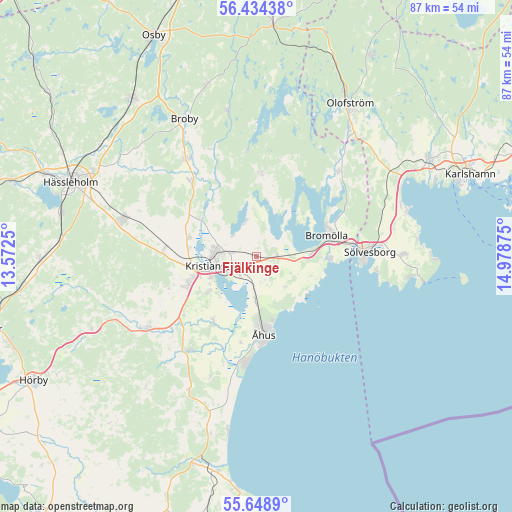
Fjälkinge GPS coordinates[2]
56° 2' 37.104" North, 14° 16' 32.232" East
| Map corner | latitude | longitude |
|---|---|---|
| Upper-left | 56.43438°, | 13.5725° |
| Center: | 56.04364°, | 14.27562° |
| Lower-right: | 55.6489°, | 14.97875° |
| Map W x H: | 87.3×87.3 km | = 54.2×54.2mi |
| max Lat: | 67.85572° ⇑91.9% North |
| Fjälkinge: | 56.04364° |
| min Lat: | ⇓8.1% South 55.34337° |
| min Long | Fjälkinge | max Long |
| 11.1712° | 14.27562° | 24.13676° |
| W 40.3%⇐ | ⇒59.7% E |
Elevation
Elevation of Fjälkinge is 26 m = 85 ft, and this is 56.6 m = 186 ft below average elevation for this country.
| Max E: |
663 m = 2175 ft | 68.9% |
| Avg. | 82.6 m = 271 ft | |
| Fjälkinge | 26 m = 85 ft | |
Min E: |
-1 m = -3 ft | 31.1% |
See also: Sweden elevation on elevation.city.
Geographical zone
Fjälkinge is located in North temperate zone (between Tropic of Cancer and the Arctic Circle). Distance of this North polar circle is 1169.7 km =726.8 mi to North.| Distance of | km | miles | from Fjälkinge |
|---|---|---|---|
| North Pole | 3775.6 | 2346 | to North |
| Arctic Circle | 1169.7 | 726.8 | to North |
| Tropic Cancer | 3625.5 | 2252.8 | to South |
| Equator | 6231.5 | 3872.1 | to South |


Nearby cities:
15 places around Fjälkinge: (largest is in red/bold)
• Arkelstorp
14.1 km =8.8 mi,  3°
3°
• Bromölla
12.6 km =7.8 mi,  73°
73°
• Färlöv
12.2 km =7.6 mi,  282°
282°
• Gualöv
8.8 km =5.5 mi,  85°
85°
• Gärds Köpinge
14.5 km =9 mi,  212°
212°
• Hammar
4.7 km =2.9 mi,  230°
230°
• Hammarslund
5.8 km =3.6 mi,  240°
240°
• Hanaskog
17.2 km =10.7 mi,  318°
318°
• Kristianstad
7.8 km =4.8 mi,  259°
259°
• Norra Åsum
10.3 km =6.4 mi, 229°
• Rinkaby
6.7 km =4.2 mi,  184°
184°
• Tollarp1
13.7 km =8.5 mi, 2°
• Valje
16.8 km =10.4 mi,  82°
82°
• Åhus
14.1 km =8.8 mi, 178°
• Önnestad
15.8 km =9.8 mi, 275°
Sources, notices
• [Note1] Compared only with cities in Sweden existing in our database
• [Src1] Map data: © OpenStreetMap contributors (CC-BY-SA)
• [Src2] Other city data from geonames.org with taken over terms of usage.
• [Src3] Geographical zone / Annual Mean Temperature by Robert A. Rohde @ Wikipedia
