Starše geodata
Starše is a seat of a first-order administrative division; located in Slovenia in Europe/Ljubljana (GMT+2) time zone. With population of 803 people, there are 295 cities with bigger population in this country. Compared to other cities in Slovenia, 75.2% of cities are located further ↓South; 81.2% of cities are located further ←West and 70.7% of cities have higher elevation than Starše. Note1


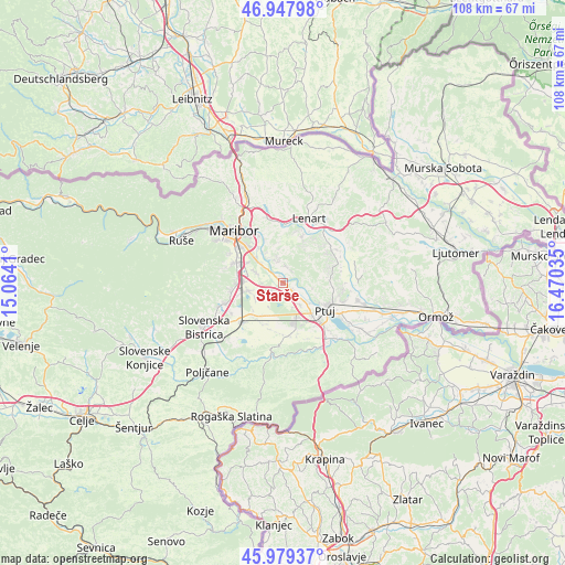
Starše GPS coordinates[2]
46° 27' 56.988" North, 15° 46' 1.992" East
| Map corner | latitude | longitude |
|---|---|---|
| Upper-left | 46.94798°, | 15.0641° |
| Center: | 46.46583°, | 15.76722° |
| Lower-right: | 45.97937°, | 16.47035° |
| Map W x H: | 107.7×107.7 km | = 66.9×66.9mi |
| max Lat: | 46.83694° ⇑24.8% North |
| Starše: | 46.46583° |
| min Lat: | ⇓75.2% South 45.47667° |
| min Long | Starše | max Long |
| 13.52639° | 15.76722° | 16.4975° |
| W 81.2%⇐ | ⇒18.8% E |
Elevation
Elevation of Starše is 240 m = 787 ft, and this is 85.6 m = 281 ft below average elevation for this country.
| Max E: |
1551 m = 5089 ft | 70.7% |
| Avg. | 325.6 m = 1068 ft | |
| Starše | 240 m = 787 ft | |
Min E: |
2 m = 7 ft | 29.3% |
See also: Slovenia elevation on elevation.city.
Geographical zone
Starše is located in North temperate zone (between Tropic of Cancer and the Arctic Circle). Distance of this North polar circle is 2234.7 km =1388.6 mi to North.| Distance of | km | miles | from Starše |
|---|---|---|---|
| North Pole | 4840.5 | 3007.7 | to North |
| Arctic Circle | 2234.7 | 1388.6 | to North |
| Tropic Cancer | 2560.6 | 1591.1 | to South |
| Equator | 5166.5 | 3210.3 | to South |


Nearby cities:
15 places around Starše: (largest is in red/bold)
• Dobrovce
5.2 km =3.2 mi,  288°
288°
• Dravski Dvor
3.9 km =2.4 mi,  272°
272°
• Dvorjane
2.8 km =1.7 mi,  354°
354°
• Gerečja Vas
5.2 km =3.2 mi,  133°
133°
• Grajenščak
4.3 km =2.7 mi,  62°
62°
• Hajdoše
5.8 km =3.6 mi, 129°
• Krčevina pri Vurbergu
3.5 km =2.2 mi,  72°
72°
• Miklavž na Dravskem Polju
7 km =4.3 mi,  309°
309°
• Prepolje
2.4 km =1.5 mi,  186°
186°
• Rače
6.8 km =4.2 mi,  256°
256°
• Skoke
6 km =3.7 mi, 291°
• Slovenja Vas
3.1 km =1.9 mi, 125°
• Spodnji Duplek
4.5 km =2.8 mi,  337°
337°
• Zgornji Duplek
6.4 km =4 mi,  326°
326°
• Zlatoličje
2.2 km =1.4 mi,  121°
121°
Sources, notices
• [Note1] Compared only with cities in Slovenia existing in our database
• [Src1] Map data: © OpenStreetMap contributors (CC-BY-SA)
• [Src2] Other city data from geonames.org with taken over terms of usage.
• [Src3] Geographical zone / Annual Mean Temperature by Robert A. Rohde @ Wikipedia
