Rače geodata
Rače (Rače-Fram) is a seat of a first-order administrative division; located in Slovenia in Europe/Ljubljana (GMT+2) time zone. With population of 2,529 people, there are 78 cities with bigger population in this country. Compared to other cities in Slovenia, 74.2% of cities are located further ↓South; 77.5% of cities are located further ←West and 63.2% of cities have higher elevation than Rače. Note1


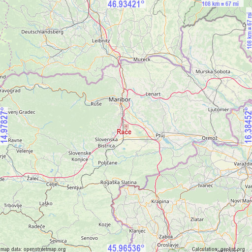
Rače GPS coordinates[2]
46° 27' 6.984" North, 15° 40' 53.004" East
| Map corner | latitude | longitude |
|---|---|---|
| Upper-left | 46.93421°, | 14.97827° |
| Center: | 46.45194°, | 15.68139° |
| Lower-right: | 45.96536°, | 16.38452° |
| Map W x H: | 107.7×107.7 km | = 66.9×66.9mi |
| max Lat: | 46.83694° ⇑25.8% North |
| Rače: | 46.45194° |
| min Lat: | ⇓74.2% South 45.47667° |
| min Long | Rače | max Long |
| 13.52639° | 15.68139° | 16.4975° |
| W 77.5%⇐ | ⇒22.5% E |
Elevation
Elevation of Rače is 262 m = 860 ft, and this is 63.6 m = 209 ft below average elevation for this country.
| Max E: |
1551 m = 5089 ft | 63.2% |
| Avg. | 325.6 m = 1068 ft | |
| Rače | 262 m = 860 ft | |
Min E: |
2 m = 7 ft | 36.8% |
See also: Slovenia elevation on elevation.city.
Geographical zone
Rače is located in North temperate zone (between Tropic of Cancer and the Arctic Circle). Distance of this North polar circle is 2236.2 km =1389.5 mi to North.| Distance of | km | miles | from Rače |
|---|---|---|---|
| North Pole | 4842.1 | 3008.7 | to North |
| Arctic Circle | 2236.2 | 1389.5 | to North |
| Tropic Cancer | 2559.1 | 1590.2 | to South |
| Equator | 5165 | 3209.4 | to South |


Nearby cities:
15 places around Rače: (largest is in red/bold)
• Dobrovce
3.6 km =2.2 mi,  27°
27°
• Dravski Dvor
3.2 km =2 mi,  57°
57°
• Fram
4 km =2.5 mi,  276°
276°
• Gaj
5.2 km =3.2 mi,  187°
187°
• Hotinja Vas
2 km =1.2 mi,  325°
325°
• Miklavž na Dravskem Polju
6.1 km =3.8 mi,  11°
11°
• Morje
4.7 km =2.9 mi,  259°
259°
• Radizel
3.2 km =2 mi,  321°
321°
• Rogoza
5.3 km =3.3 mi,  1°
1°
• Skoke
3.9 km =2.4 mi, 14°
• Slivnica pri Mariboru
3.4 km =2.1 mi, 324°
• Spodnja Polskava
5.6 km =3.5 mi,  215°
215°
• Spodnje Hoče
5.9 km =3.7 mi,  335°
335°
• Zgornja Polskava
6.1 km =3.8 mi,  241°
241°
• Zgornje Hoče
6.3 km =3.9 mi,  314°
314°
Sources, notices
• [Note1] Compared only with cities in Slovenia existing in our database
• [Src1] Map data: © OpenStreetMap contributors (CC-BY-SA)
• [Src2] Other city data from geonames.org with taken over terms of usage.
• [Src3] Geographical zone / Annual Mean Temperature by Robert A. Rohde @ Wikipedia
