Grajenščak geodata
Grajenščak (Ptuj) is a populated place; located in Slovenia in Europe/Ljubljana (GMT+2) time zone. With population of 506 people, there are 547 cities with bigger population in this country. Compared to other cities in Slovenia, 77.2% of cities are located further ↓South; 83.3% of cities are located further ←West and 55.5% of cities have lower elevation than Grajenščak. Note1


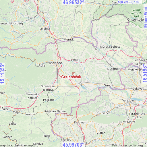
Grajenščak GPS coordinates[2]
46° 28' 59.988" North, 15° 49' 0.012" East
| Map corner | latitude | longitude |
|---|---|---|
| Upper-left | 46.96532°, | 15.11355° |
| Center: | 46.48333°, | 15.81667° |
| Lower-right: | 45.99703°, | 16.5198° |
| Map W x H: | 107.7×107.7 km | = 66.9×66.9mi |
| max Lat: | 46.83694° ⇑22.8% North |
| Grajenščak: | 46.48333° |
| min Lat: | ⇓77.2% South 45.47667° |
| min Long | Grajenščak | max Long |
| 13.52639° | 15.81667° | 16.4975° |
| W 83.3%⇐ | ⇒16.7% E |
Elevation
Elevation of Grajenščak is 311 m = 1020 ft, and this is 14.6 m = 48 ft below average elevation for this country.
| Max E: |
1551 m = 5089 ft | 44.5% |
| Avg. | 325.6 m = 1068 ft | |
| Grajenščak | 311 m = 1020 ft | |
Min E: |
2 m = 7 ft | 55.5% |
See also: Slovenia elevation on elevation.city.
Geographical zone
Grajenščak is located in North temperate zone (between Tropic of Cancer and the Arctic Circle). Distance of this North polar circle is 2232.7 km =1387.3 mi to North.| Distance of | km | miles | from Grajenščak |
|---|---|---|---|
| North Pole | 4838.6 | 3006.6 | to North |
| Arctic Circle | 2232.7 | 1387.3 | to North |
| Tropic Cancer | 2562.5 | 1592.3 | to South |
| Equator | 5168.5 | 3211.6 | to South |


Nearby cities:
15 places around Grajenščak: (largest is in red/bold)
• Destrnik
4.9 km =3 mi,  77°
77°
• Dvorjane
4.2 km =2.6 mi,  282°
282°
• Gerečja Vas
5.6 km =3.5 mi,  180°
180°
• Hajdoše
5.7 km =3.5 mi,  172°
172°
• Krčevina pri Vurbergu
1 km =0.6 mi,  206°
206°
• Mestni Vrh
5.8 km =3.6 mi,  140°
140°
• Prepolje
5.9 km =3.7 mi,  222°
222°
• Slovenja Vas
3.9 km =2.4 mi,  199°
199°
• Spodnja Voličina
6.8 km =4.2 mi,  358°
358°
• Spodnji Duplek
5.9 km =3.7 mi,  291°
291°
• Starše
4.3 km =2.7 mi,  242°
242°
• Trnovska Vas
6.7 km =4.2 mi,  52°
52°
• Zgornja Voličina
6.1 km =3.8 mi,  335°
335°
• Zimica
7.5 km =4.7 mi,  317°
317°
• Zlatoličje
3.7 km =2.3 mi, 212°
Sources, notices
• [Note1] Compared only with cities in Slovenia existing in our database
• [Src1] Map data: © OpenStreetMap contributors (CC-BY-SA)
• [Src2] Other city data from geonames.org with taken over terms of usage.
• [Src3] Geographical zone / Annual Mean Temperature by Robert A. Rohde @ Wikipedia
