Šentjernej geodata
Šentjernej is a seat of a first-order administrative division; located in Slovenia in Europe/Ljubljana (GMT+2) time zone. With population of 1,423 people, there are 153 cities with bigger population in this country. Compared to other cities in Slovenia, 86.7% of cities are located further ↑North; 66% of cities are located further ←West and 80.7% of cities have higher elevation than Šentjernej. Note1


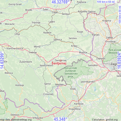
Šentjernej GPS coordinates[2]
45° 50' 24" North, 15° 20' 9.996" East
| Map corner | latitude | longitude |
|---|---|---|
| Upper-left | 46.32769°, | 14.63299° |
| Center: | 45.84°, | 15.33611° |
| Lower-right: | 45.348°, | 16.03924° |
| Map W x H: | 108.9×108.9 km | = 67.7×67.7mi |
| max Lat: | 46.83694° ⇑86.7% North |
| Šentjernej: | 45.84° |
| min Lat: | ⇓13.3% South 45.47667° |
| min Long | Šentjernej | max Long |
| 13.52639° | 15.33611° | 16.4975° |
| W 66%⇐ | ⇒34% E |
Elevation
Elevation of Šentjernej is 193 m = 633 ft, and this is 132.6 m = 435 ft below average elevation for this country.
| Max E: |
1551 m = 5089 ft | 80.7% |
| Avg. | 325.6 m = 1068 ft | |
| Šentjernej | 193 m = 633 ft | |
Min E: |
2 m = 7 ft | 19.3% |
See also: Slovenia elevation on elevation.city.
Geographical zone
Šentjernej is located in North temperate zone (between Tropic of Cancer and the Arctic Circle). Distance of this North polar circle is 2304.2 km =1431.8 mi to North.| Distance of | km | miles | from Šentjernej |
|---|---|---|---|
| North Pole | 4910.1 | 3051 | to North |
| Arctic Circle | 2304.2 | 1431.8 | to North |
| Tropic Cancer | 2491 | 1547.8 | to South |
| Equator | 5096.9 | 3167.1 | to South |


Nearby cities:
15 places around Šentjernej: (largest is in red/bold)
• Dolenji Boštanj
19.2 km =11.9 mi,  349°
349°
• Gabrje
7.9 km =4.9 mi,  216°
216°
• Kostanjevica na Krki
6.7 km =4.2 mi,  84°
84°
• Krška Vas
19.1 km =11.9 mi,  69°
69°
• Krško
17.9 km =11.1 mi,  42°
42°
• Leskovec pri Krškem
14.9 km =9.3 mi, 44°
• Mirna Peč
19.7 km =12.2 mi,  276°
276°
• Mokronog
18.4 km =11.4 mi,  304°
304°
• Novo Mesto
13.6 km =8.5 mi,  252°
252°
• Otočec
8.6 km =5.3 mi,  269°
269°
• Sevnica
18.7 km =11.6 mi,  355°
355°
• Velike Brusnice
7.3 km =4.5 mi,  236°
236°
• Škocjan
8.2 km =5.1 mi,  334°
334°
• Šmarjeta
8.2 km =5.1 mi,  305°
305°
• Šmarješke Toplice
9.2 km =5.7 mi,  285°
285°
Sources, notices
• [Note1] Compared only with cities in Slovenia existing in our database
• [Src1] Map data: © OpenStreetMap contributors (CC-BY-SA)
• [Src2] Other city data from geonames.org with taken over terms of usage.
• [Src3] Geographical zone / Annual Mean Temperature by Robert A. Rohde @ Wikipedia
