Škocjan geodata
Škocjan is a seat of a first-order administrative division; located in Slovenia in Europe/Ljubljana (GMT+2) time zone. With population of 246 people, there are 588 cities with bigger population in this country. Compared to other cities in Slovenia, 82.3% of cities are located further ↑North; 64.3% of cities are located further ←West and 88.8% of cities have higher elevation than Škocjan. Note1


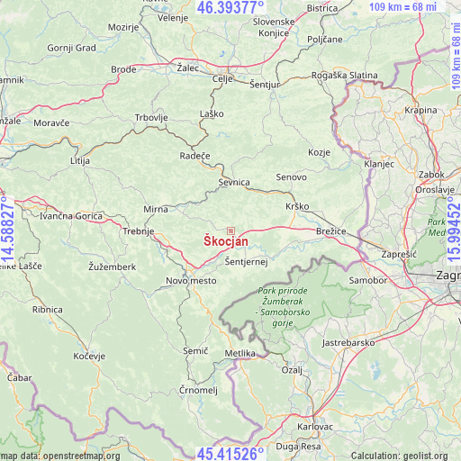
Škocjan GPS coordinates[2]
45° 54' 24.012" North, 15° 17' 29.004" East
| Map corner | latitude | longitude |
|---|---|---|
| Upper-left | 46.39377°, | 14.58827° |
| Center: | 45.90667°, | 15.29139° |
| Lower-right: | 45.41526°, | 15.99452° |
| Map W x H: | 108.8×108.8 km | = 67.6×67.6mi |
| max Lat: | 46.83694° ⇑82.3% North |
| Škocjan: | 45.90667° |
| min Lat: | ⇓17.7% South 45.47667° |
| min Long | Škocjan | max Long |
| 13.52639° | 15.29139° | 16.4975° |
| W 64.3%⇐ | ⇒35.7% E |
Elevation
Elevation of Škocjan is 168 m = 551 ft, and this is 157.6 m = 517 ft below average elevation for this country.
| Max E: |
1551 m = 5089 ft | 88.8% |
| Avg. | 325.6 m = 1068 ft | |
| Škocjan | 168 m = 551 ft | |
Min E: |
2 m = 7 ft | 11.2% |
See also: Slovenia elevation on elevation.city.
Geographical zone
Škocjan is located in North temperate zone (between Tropic of Cancer and the Arctic Circle). Distance of this North polar circle is 2296.8 km =1427.2 mi to North.| Distance of | km | miles | from Škocjan |
|---|---|---|---|
| North Pole | 4902.7 | 3046.4 | to North |
| Arctic Circle | 2296.8 | 1427.2 | to North |
| Tropic Cancer | 2498.4 | 1552.4 | to South |
| Equator | 5104.3 | 3171.7 | to South |


Nearby cities:
15 places around Škocjan: (largest is in red/bold)
• Dolenji Boštanj
11.4 km =7.1 mi,  359°
359°
• Gabrje
13.9 km =8.6 mi,  185°
185°
• Kostanjevica na Krki
12.2 km =7.6 mi,  123°
123°
• Krmelj
11.7 km =7.3 mi,  317°
317°
• Krško
16.6 km =10.3 mi,  69°
69°
• Leskovec pri Krškem
14.3 km =8.9 mi,  76°
76°
• Mokronog
12 km =7.5 mi,  284°
284°
• Novo Mesto
14.8 km =9.2 mi,  219°
219°
• Otočec
9 km =5.6 mi,  214°
214°
• Sevnica
11.4 km =7.1 mi,  9°
9°
• Slovenska Vas
16.4 km =10.2 mi,  289°
289°
• Velike Brusnice
11.7 km =7.3 mi, 192°
• Šentjernej
8.2 km =5.1 mi,  154°
154°
• Šmarjeta
4.1 km =2.5 mi,  230°
230°
• Šmarješke Toplice
7.3 km =4.5 mi, 227°
Sources, notices
• [Note1] Compared only with cities in Slovenia existing in our database
• [Src1] Map data: © OpenStreetMap contributors (CC-BY-SA)
• [Src2] Other city data from geonames.org with taken over terms of usage.
• [Src3] Geographical zone / Annual Mean Temperature by Robert A. Rohde @ Wikipedia
