Radizel geodata
Radizel (Hoče-Slivnica) is a populated place; located in Slovenia in Europe/Ljubljana (GMT+2) time zone. With population of 1,698 people, there are 121 cities with bigger population in this country. Compared to other cities in Slovenia, 76.3% of cities are located further ↓South; 75.8% of cities are located further ←West and 56.5% of cities have higher elevation than Radizel. Note1


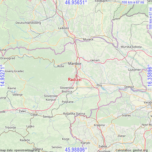
Radizel GPS coordinates[2]
46° 28' 27.984" North, 15° 39' 20.988" East
| Map corner | latitude | longitude |
|---|---|---|
| Upper-left | 46.95651°, | 14.95271° |
| Center: | 46.47444°, | 15.65583° |
| Lower-right: | 45.98806°, | 16.35896° |
| Map W x H: | 107.7×107.7 km | = 66.9×66.9mi |
| max Lat: | 46.83694° ⇑23.7% North |
| Radizel: | 46.47444° |
| min Lat: | ⇓76.3% South 45.47667° |
| min Long | Radizel | max Long |
| 13.52639° | 15.65583° | 16.4975° |
| W 75.8%⇐ | ⇒24.2% E |
Elevation
Elevation of Radizel is 281 m = 922 ft, and this is 44.6 m = 146 ft below average elevation for this country.
| Max E: |
1551 m = 5089 ft | 56.5% |
| Avg. | 325.6 m = 1068 ft | |
| Radizel | 281 m = 922 ft | |
Min E: |
2 m = 7 ft | 43.5% |
See also: Slovenia elevation on elevation.city.
Geographical zone
Radizel is located in North temperate zone (between Tropic of Cancer and the Arctic Circle). Distance of this North polar circle is 2233.7 km =1388 mi to North.| Distance of | km | miles | from Radizel |
|---|---|---|---|
| North Pole | 4839.6 | 3007.2 | to North |
| Arctic Circle | 2233.7 | 1388 | to North |
| Tropic Cancer | 2561.6 | 1591.7 | to South |
| Equator | 5167.5 | 3210.9 | to South |


Nearby cities:
15 places around Radizel: (largest is in red/bold)
• Dobrovce
3.7 km =2.3 mi,  79°
79°
• Dravski Dvor
4.7 km =2.9 mi,  99°
99°
• Fram
2.8 km =1.7 mi,  223°
223°
• Hotinja Vas
1.2 km =0.7 mi,  136°
136°
• Miklavž na Dravskem Polju
4.7 km =2.9 mi,  42°
42°
• Morje
4.3 km =2.7 mi, 218°
• Pivola
4.1 km =2.5 mi,  319°
319°
• Razvanje
4.7 km =2.9 mi,  341°
341°
• Rače
3.2 km =2 mi, 141°
• Rogoza
3.5 km =2.2 mi, 36°
• Skoke
3.2 km =2 mi,  66°
66°
• Slivnica pri Mariboru
0.2 km =0.1 mi,  0°
0°
• Spodnje Hoče
2.9 km =1.8 mi,  351°
351°
• Zgornja Polskava
6.4 km =4 mi,  211°
211°
• Zgornje Hoče
3.2 km =2 mi,  307°
307°
Sources, notices
• [Note1] Compared only with cities in Slovenia existing in our database
• [Src1] Map data: © OpenStreetMap contributors (CC-BY-SA)
• [Src2] Other city data from geonames.org with taken over terms of usage.
• [Src3] Geographical zone / Annual Mean Temperature by Robert A. Rohde @ Wikipedia
