Morje geodata
Morje (Rače-Fram) is a populated place; located in Slovenia in Europe/Ljubljana (GMT+2) time zone. With population of 1,032 people, there are 206 cities with bigger population in this country. Compared to other cities in Slovenia, 73.5% of cities are located further ↓South; 73.7% of cities are located further ←West and 55% of cities have lower elevation than Morje. Note1


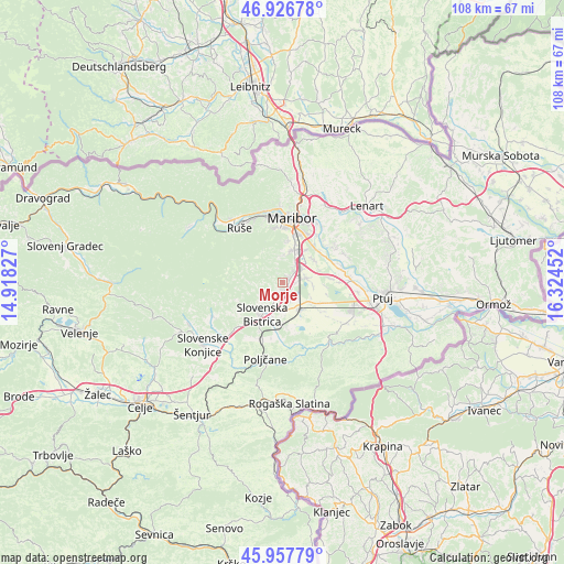
Morje GPS coordinates[2]
46° 26' 39.984" North, 15° 37' 17.004" East
| Map corner | latitude | longitude |
|---|---|---|
| Upper-left | 46.92678°, | 14.91827° |
| Center: | 46.44444°, | 15.62139° |
| Lower-right: | 45.95779°, | 16.32452° |
| Map W x H: | 107.7×107.7 km | = 66.9×66.9mi |
| max Lat: | 46.83694° ⇑26.5% North |
| Morje: | 46.44444° |
| min Lat: | ⇓73.5% South 45.47667° |
| min Long | Morje | max Long |
| 13.52639° | 15.62139° | 16.4975° |
| W 73.7%⇐ | ⇒26.3% E |
Elevation
Elevation of Morje is 310 m = 1017 ft, and this is 15.6 m = 51 ft below average elevation for this country.
| Max E: |
1551 m = 5089 ft | 45% |
| Avg. | 325.6 m = 1068 ft | |
| Morje | 310 m = 1017 ft | |
Min E: |
2 m = 7 ft | 55% |
See also: Slovenia elevation on elevation.city.
Geographical zone
Morje is located in North temperate zone (between Tropic of Cancer and the Arctic Circle). Distance of this North polar circle is 2237 km =1390 mi to North.| Distance of | km | miles | from Morje |
|---|---|---|---|
| North Pole | 4842.9 | 3009.2 | to North |
| Arctic Circle | 2237 | 1390 | to North |
| Tropic Cancer | 2558.2 | 1589.6 | to South |
| Equator | 5164.1 | 3208.8 | to South |


Nearby cities:
15 places around Morje: (largest is in red/bold)
• Fram
1.4 km =0.9 mi,  27°
27°
• Gabernik
2.9 km =1.8 mi,  226°
226°
• Gaj
5.9 km =3.7 mi,  137°
137°
• Hotinja Vas
4.3 km =2.7 mi,  54°
54°
• Kovača Vas
6 km =3.7 mi, 231°
• Pivola
6.5 km =4 mi,  359°
359°
• Pragersko
6.1 km =3.8 mi,  150°
150°
• Radizel
4.3 km =2.7 mi,  38°
38°
• Rače
4.7 km =2.9 mi,  79°
79°
• Slivnica pri Mariboru
4.4 km =2.7 mi, 36°
• Slovenska Bistrica
6.8 km =4.2 mi,  212°
212°
• Spodnja Polskava
4 km =2.5 mi,  160°
160°
• Spodnje Hoče
6.6 km =4.1 mi,  19°
19°
• Zgornja Polskava
2.2 km =1.4 mi,  198°
198°
• Zgornje Hoče
5.3 km =3.3 mi,  1°
1°
Sources, notices
• [Note1] Compared only with cities in Slovenia existing in our database
• [Src1] Map data: © OpenStreetMap contributors (CC-BY-SA)
• [Src2] Other city data from geonames.org with taken over terms of usage.
• [Src3] Geographical zone / Annual Mean Temperature by Robert A. Rohde @ Wikipedia
