Komenda geodata
Komenda is a seat of a first-order administrative division; located in Slovenia in Europe/Ljubljana (GMT+2) time zone. With population of 881 people, there are 258 cities with bigger population in this country. Compared to other cities in Slovenia, 57.7% of cities are located further ↑North; 65.2% of cities are located further →East and 63% of cities have lower elevation than Komenda. Note1


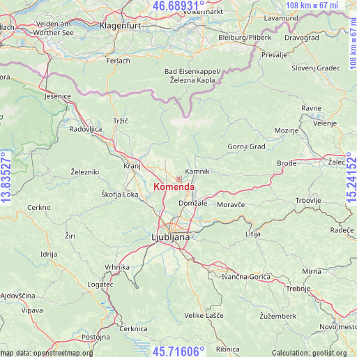
Komenda GPS coordinates[2]
46° 12' 17.424" North, 14° 32' 18.204" East
| Map corner | latitude | longitude |
|---|---|---|
| Upper-left | 46.68931°, | 13.83527° |
| Center: | 46.20484°, | 14.53839° |
| Lower-right: | 45.71606°, | 15.24152° |
| Map W x H: | 108.2×108.2 km | = 67.2×67.2mi |
| max Lat: | 46.83694° ⇑57.7% North |
| Komenda: | 46.20484° |
| min Lat: | ⇓42.3% South 45.47667° |
| min Long | Komenda | max Long |
| 13.52639° | 14.53839° | 16.4975° |
| W 34.8%⇐ | ⇒65.2% E |
Elevation
Elevation of Komenda is 338 m = 1109 ft, and this is 12.4 m = 41 ft above average elevation for this country.
| Max E: |
1551 m = 5089 ft | 37% |
| Komenda | 338 m 1109 ft | |
| Avg. | 325.6 m = 1068 ft | |
Min E: |
2 m = 7 ft | 63% |
See also: Slovenia elevation on elevation.city.
Geographical zone
Komenda is located in North temperate zone (between Tropic of Cancer and the Arctic Circle). Distance of this North polar circle is 2263.7 km =1406.6 mi to North.| Distance of | km | miles | from Komenda |
|---|---|---|---|
| North Pole | 4869.6 | 3025.8 | to North |
| Arctic Circle | 2263.7 | 1406.6 | to North |
| Tropic Cancer | 2531.6 | 1573.1 | to South |
| Equator | 5137.5 | 3192.3 | to South |


Nearby cities:
15 places around Komenda: (largest is in red/bold)
• Cerklje na Gorenjskem
6.7 km =4.2 mi,  325°
325°
• Homec
5.3 km =3.3 mi,  116°
116°
• Kamnik
6.1 km =3.8 mi,  67°
67°
• Loka pri Mengšu
6.4 km =4 mi,  161°
161°
• Mekinje
6.8 km =4.2 mi,  62°
62°
• Mengeš
5.1 km =3.2 mi,  146°
146°
• Moste
1.5 km =0.9 mi,  137°
137°
• Nožice
4.9 km =3 mi, 117°
• Podgorje
3.7 km =2.3 mi, 69°
• Preserje pri Radomljah
6 km =3.7 mi,  131°
131°
• Radomlje
6.7 km =4.2 mi, 121°
• Suhadole
2.6 km =1.6 mi, 159°
• Vodice
3.7 km =2.3 mi,  243°
243°
• Zgornji Brnik
5.6 km =3.5 mi,  312°
312°
• Šmarca
4.7 km =2.9 mi,  105°
105°
Sources, notices
• [Note1] Compared only with cities in Slovenia existing in our database
• [Src1] Map data: © OpenStreetMap contributors (CC-BY-SA)
• [Src2] Other city data from geonames.org with taken over terms of usage.
• [Src3] Geographical zone / Annual Mean Temperature by Robert A. Rohde @ Wikipedia
