Šalara geodata
Šalara (Koper-Capodistria) is a populated place; located in Slovenia in Europe/Ljubljana (GMT+2) time zone. With population of 550 people, there are 483 cities with bigger population in this country. Compared to other cities in Slovenia, 98.2% of cities are located further ↑North; 94.7% of cities are located further →East and 96.3% of cities have higher elevation than Šalara. Note1


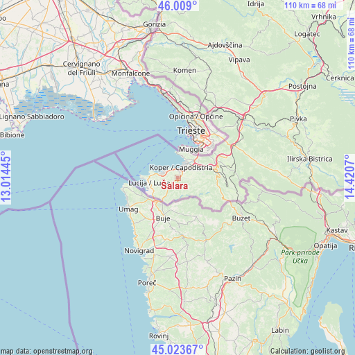
Šalara GPS coordinates[2]
45° 31' 6.564" North, 13° 43' 3.252" East
| Map corner | latitude | longitude |
|---|---|---|
| Upper-left | 46.009°, | 13.01445° |
| Center: | 45.51849°, | 13.71757° |
| Lower-right: | 45.02367°, | 14.4207° |
| Map W x H: | 109.6×109.6 km | = 68.1×68.1mi |
| max Lat: | 46.83694° ⇑98.2% North |
| Šalara: | 45.51849° |
| min Lat: | ⇓1.8% South 45.47667° |
| min Long | Šalara | max Long |
| 13.52639° | 13.71757° | 16.4975° |
| W 5.3%⇐ | ⇒94.7% E |
Elevation
Elevation of Šalara is 67 m = 220 ft, and this is 258.6 m = 848 ft below average elevation for this country.
| Max E: |
1551 m = 5089 ft | 96.3% |
| Avg. | 325.6 m = 1068 ft | |
| Šalara | 67 m = 220 ft | |
Min E: |
2 m = 7 ft | 3.7% |
See also: Slovenia elevation on elevation.city.
Geographical zone
Šalara is located in North temperate zone (between Tropic of Cancer and the Arctic Circle). Distance of this North polar circle is 2340 km =1454 mi to North.| Distance of | km | miles | from Šalara |
|---|---|---|---|
| North Pole | 4945.9 | 3073.2 | to North |
| Arctic Circle | 2340 | 1454 | to North |
| Tropic Cancer | 2455.3 | 1525.7 | to South |
| Equator | 5061.2 | 3144.9 | to South |


Nearby cities:
15 places around Šalara: (largest is in red/bold)
• Bertoki
4.9 km =3 mi,  52°
52°
• Bonini
5.1 km =3.2 mi,  77°
77°
• Bošamarin
1.4 km =0.9 mi, 82°
• Gažon
1.3 km =0.8 mi,  272°
272°
• Izola
4.8 km =3 mi,  295°
295°
• Jagodje
5.6 km =3.5 mi,  281°
281°
• Kampel
2.3 km =1.4 mi,  103°
103°
• Koper
3.3 km =2.1 mi,  16°
16°
• Korte
4.8 km =3 mi,  229°
229°
• Pobegi
6.5 km =4 mi,  69°
69°
• Prade
5.1 km =3.2 mi,  62°
62°
• Vanganel
4.5 km =2.8 mi,  91°
91°
• Šared
5 km =3.1 mi,  260°
260°
• Škocjan
4 km =2.5 mi, 64°
• Šmarje
1.9 km =1.2 mi,  179°
179°
Sources, notices
• [Note1] Compared only with cities in Slovenia existing in our database
• [Src1] Map data: © OpenStreetMap contributors (CC-BY-SA)
• [Src2] Other city data from geonames.org with taken over terms of usage.
• [Src3] Geographical zone / Annual Mean Temperature by Robert A. Rohde @ Wikipedia
