Koper geodata
Koper (Koper-Capodistria) is a seat of a first-order administrative division; located in Slovenia in Europe/Ljubljana (GMT+2) time zone. With population of 24,996 people, there are 5 cities with bigger population in this country. Compared to other cities in Slovenia, 95.5% of cities are located further ↑North; 94.2% of cities are located further →East and 99.2% of cities have higher elevation than Koper. Note1


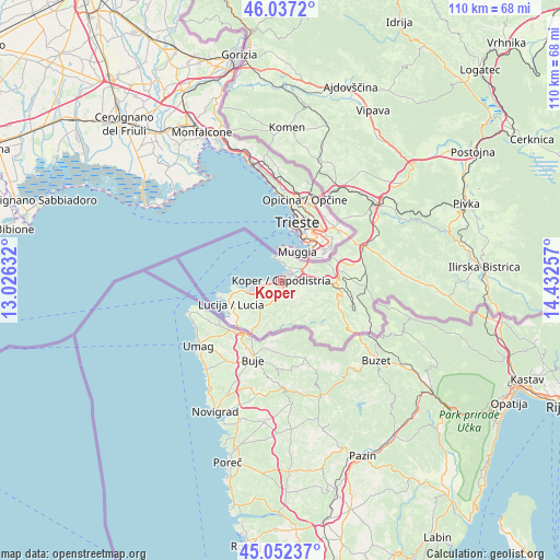
Koper GPS coordinates[2]
45° 32' 48.984" North, 13° 43' 45.984" East
| Map corner | latitude | longitude |
|---|---|---|
| Upper-left | 46.0372°, | 13.02632° |
| Center: | 45.54694°, | 13.72944° |
| Lower-right: | 45.05237°, | 14.43257° |
| Map W x H: | 109.5×109.5 km | = 68×68mi |
| max Lat: | 46.83694° ⇑95.5% North |
| Koper: | 45.54694° |
| min Lat: | ⇓4.5% South 45.47667° |
| min Long | Koper | max Long |
| 13.52639° | 13.72944° | 16.4975° |
| W 5.8%⇐ | ⇒94.2% E |
Elevation
Elevation of Koper is 15 m = 49 ft, and this is 310.6 m = 1019 ft below average elevation for this country.
| Max E: |
1551 m = 5089 ft | 99.2% |
| Avg. | 325.6 m = 1068 ft | |
| Koper | 15 m = 49 ft | |
Min E: |
2 m = 7 ft | 0.8% |
See also: Slovenia elevation on elevation.city.
Geographical zone
Koper is located in North temperate zone (between Tropic of Cancer and the Arctic Circle). Distance of this North polar circle is 2336.8 km =1452 mi to North.| Distance of | km | miles | from Koper |
|---|---|---|---|
| North Pole | 4942.7 | 3071.3 | to North |
| Arctic Circle | 2336.8 | 1452 | to North |
| Tropic Cancer | 2458.4 | 1527.6 | to South |
| Equator | 5064.3 | 3146.8 | to South |


Nearby cities:
15 places around Koper: (largest is in red/bold)
• Ankaran
3.6 km =2.2 mi,  8°
8°
• Bertoki
3 km =1.9 mi,  92°
92°
• Bonini
4.6 km =2.9 mi,  116°
116°
• Bošamarin
3 km =1.9 mi,  170°
170°
• Gažon
3.8 km =2.4 mi,  215°
215°
• Hrvatini
4.5 km =2.8 mi,  28°
28°
• Izola
5.4 km =3.4 mi,  258°
258°
• Kampel
3.9 km =2.4 mi,  161°
161°
• Kolomban
5 km =3.1 mi,  16°
16°
• Pobegi
5.3 km =3.3 mi,  99°
99°
• Prade
3.7 km =2.3 mi, 101°
• Vanganel
4.9 km =3 mi,  132°
132°
• Šalara
3.3 km =2.1 mi,  196°
196°
• Škocjan
3 km =1.9 mi, 119°
• Šmarje
5.1 km =3.2 mi,  190°
190°
Sources, notices
• [Note1] Compared only with cities in Slovenia existing in our database
• [Src1] Map data: © OpenStreetMap contributors (CC-BY-SA)
• [Src2] Other city data from geonames.org with taken over terms of usage.
• [Src3] Geographical zone / Annual Mean Temperature by Robert A. Rohde @ Wikipedia
