Tartouss geodata
Tartouss (Tartus) is a seat of a first-order administrative division; located in Syria in Asia/Damascus (GMT+3) time zone. With population of 89,457 people, there are 13 cities with bigger population in this country. Compared to other cities in Syria, 60.1% of cities are located further ↑North; 97.9% of cities are located further →East and 99.3% of cities have higher elevation than Tartouss. Note1


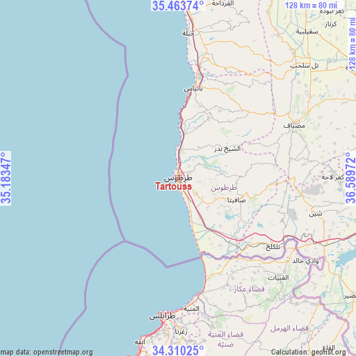
Tartouss GPS coordinates[2]
34° 53' 20.472" North, 35° 53' 11.724" East
| Map corner | latitude | longitude |
|---|---|---|
| Upper-left | 35.46374°, | 35.18347° |
| Center: | 34.88902°, | 35.88659° |
| Lower-right: | 34.31025°, | 36.58972° |
| Map W x H: | 128.3×128.3 km | = 79.7×79.7mi |
| max Lat: | 37.17701° ⇑60.1% North |
| Tartouss: | 34.88902° |
| min Lat: | ⇓39.9% South 32.39332° |
| min Long | Tartouss | max Long |
| 35.75572° | 35.88659° | 42.14006° |
| W 2.1%⇐ | ⇒97.9% E |
Elevation
Elevation of Tartouss is 20 m = 66 ft, and this is 509.1 m = 1670 ft below average elevation for this country.
| Max E: |
1640 m = 5381 ft | 99.3% |
| Avg. | 529.1 m = 1736 ft | |
| Tartouss | 20 m = 66 ft | |
Min E: |
4 m = 13 ft | 0.7% |
See also: Tartouss elevation on elevation.city.
Geographical zone
Tartouss is located in North temperate zone (between Tropic of Cancer and the Arctic Circle). Distance of this Northern Tropic circle is 1273.4 km =791.3 mi to South.| Distance of | km | miles | from Tartouss |
|---|---|---|---|
| North Pole | 6127.8 | 3807.6 | to North |
| Arctic Circle | 3521.9 | 2188.4 | to North |
| Tropic Cancer | 1273.4 | 791.3 | to South |
| Equator | 3879.3 | 2410.5 | to South |


Nearby cities:
15 places around Tartouss: (largest is in red/bold)
• Ad Duraykīsh
23.4 km =14.5 mi,  88°
88°
• Al Qamşīyah
19.9 km =12.4 mi,  35°
35°
• Al Ḩamīdīyah
20.3 km =12.6 mi,  162°
162°
• Ar Rawḑah
20.5 km =12.7 mi,  6°
6°
• Arwād
4.5 km =2.8 mi,  214°
214°
• As Sawdā
11.5 km =7.1 mi,  27°
27°
• As Sīsnīyah
26.3 km =16.3 mi,  117°
117°
• Ash Shaykh Badr
21.3 km =13.2 mi,  57°
57°
• Aş Şafşāfah
22.9 km =14.2 mi,  138°
138°
• Junaynat Raslān
22.1 km =13.7 mi,  78°
78°
• Khirbat al Ma‘azzah
14 km =8.7 mi,  132°
132°
• Ra’s al Khashūfah
16.6 km =10.3 mi,  114°
114°
• Satita
22.4 km =13.9 mi, 109°
• Ḩammām Wāşil
27.5 km =17.1 mi, 41°
• Ḩimmīn
14.1 km =8.8 mi, 84°
Sources, notices
• [Note1] Compared only with cities in Syria existing in our database
• [Src1] Map data: © OpenStreetMap contributors (CC-BY-SA)
• [Src2] Other city data from geonames.org with taken over terms of usage.
• [Src3] Geographical zone / Annual Mean Temperature by Robert A. Rohde @ Wikipedia
