Bāniyās geodata
Bāniyās (Tartus) is a seat of a second-order administrative division; located in Syria in Asia/Damascus (GMT+3) time zone. With population of 39,066 people, there are 35 cities with bigger population in this country. Compared to other cities in Syria, 51.2% of cities are located further ↓South; 95.4% of cities are located further →East and 98.2% of cities have higher elevation than Bāniyās. Note1


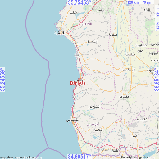
Bāniyās GPS coordinates[2]
35° 10' 54.768" North, 35° 56' 55.356" East
| Map corner | latitude | longitude |
|---|---|---|
| Upper-left | 35.75453°, | 35.24559° |
| Center: | 35.18188°, | 35.94871° |
| Lower-right: | 34.60517°, | 36.65184° |
| Map W x H: | 127.8×127.8 km | = 79.4×79.4mi |
| max Lat: | 37.17701° ⇑48.8% North |
| Bāniyās: | 35.18188° |
| min Lat: | ⇓51.2% South 32.39332° |
| min Long | Bāniyās | max Long |
| 35.75572° | 35.94871° | 42.14006° |
| W 4.6%⇐ | ⇒95.4% E |
Elevation
Elevation of Bāniyās is 31 m = 102 ft, and this is 498.1 m = 1634 ft below average elevation for this country.
| Max E: |
1640 m = 5381 ft | 98.2% |
| Avg. | 529.1 m = 1736 ft | |
| Bāniyās | 31 m = 102 ft | |
Min E: |
4 m = 13 ft | 1.8% |
See also: Syria elevation on elevation.city.
Geographical zone
Bāniyās is located in North temperate zone (between Tropic of Cancer and the Arctic Circle). Distance of this Northern Tropic circle is 1305.9 km =811.4 mi to South.| Distance of | km | miles | from Bāniyās |
|---|---|---|---|
| North Pole | 6095.2 | 3787.4 | to North |
| Arctic Circle | 3489.3 | 2168.1 | to North |
| Tropic Cancer | 1305.9 | 811.4 | to South |
| Equator | 3911.9 | 2430.7 | to South |


Nearby cities:
15 places around Bāniyās: (largest is in red/bold)
• Ad Dālīyah
18.7 km =11.6 mi,  71°
71°
• Al Qadmūs
21.3 km =13.2 mi,  115°
115°
• Al Qamşīyah
17.5 km =10.9 mi,  160°
160°
• Al Quţaylibīyah
13.7 km =8.5 mi,  26°
26°
• Al ‘Annāzah
10.7 km =6.6 mi,  82°
82°
• Ar Rawḑah
12.6 km =7.8 mi,  194°
194°
• As Sawdā
22.3 km =13.9 mi,  181°
181°
• Ash Shaykh Badr
24.4 km =15.2 mi,  149°
149°
• Aţ Ţawāḩīn
24.9 km =15.5 mi,  104°
104°
• Bayt Yāshūţ
20.8 km =12.9 mi,  46°
46°
• Jablah
20.1 km =12.5 mi,  354°
354°
• Tālīn
8.5 km =5.3 mi, 115°
• Ḩammām Wāşil
17.3 km =10.7 mi,  133°
133°
• ‘Ayn Shiqāq
24.8 km =15.4 mi,  17°
17°
• ‘Ayn ash Sharqīyah
21.6 km =13.4 mi,  39°
39°
Sources, notices
• [Note1] Compared only with cities in Syria existing in our database
• [Src1] Map data: © OpenStreetMap contributors (CC-BY-SA)
• [Src2] Other city data from geonames.org with taken over terms of usage.
• [Src3] Geographical zone / Annual Mean Temperature by Robert A. Rohde @ Wikipedia
