Jablah geodata
Jablah (Latakia) is a seat of a second-order administrative division; located in Syria in Asia/Damascus (GMT+3) time zone. With population of 65,915 people, there are 18 cities with bigger population in this country. Compared to other cities in Syria, 57.6% of cities are located further ↓South; 96.1% of cities are located further →East and 98.9% of cities have higher elevation than Jablah. Note1


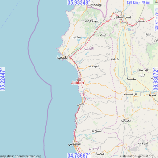
Jablah GPS coordinates[2]
35° 21' 43.596" North, 35° 55' 39.324" East
| Map corner | latitude | longitude |
|---|---|---|
| Upper-left | 35.93348°, | 35.22447° |
| Center: | 35.36211°, | 35.92759° |
| Lower-right: | 34.78667°, | 36.63072° |
| Map W x H: | 127.5×127.5 km | = 79.2×79.2mi |
| max Lat: | 37.17701° ⇑42.4% North |
| Jablah: | 35.36211° |
| min Lat: | ⇓57.6% South 32.39332° |
| min Long | Jablah | max Long |
| 35.75572° | 35.92759° | 42.14006° |
| W 3.9%⇐ | ⇒96.1% E |
Elevation
Elevation of Jablah is 26 m = 85 ft, and this is 503.1 m = 1651 ft below average elevation for this country.
| Max E: |
1640 m = 5381 ft | 98.9% |
| Avg. | 529.1 m = 1736 ft | |
| Jablah | 26 m = 85 ft | |
Min E: |
4 m = 13 ft | 1.1% |
See also: Jablah elevation on elevation.city.
Geographical zone
Jablah is located in North temperate zone (between Tropic of Cancer and the Arctic Circle). Distance of this Northern Tropic circle is 1326 km =823.9 mi to South.| Distance of | km | miles | from Jablah |
|---|---|---|---|
| North Pole | 6075.2 | 3775 | to North |
| Arctic Circle | 3469.3 | 2155.7 | to North |
| Tropic Cancer | 1326 | 823.9 | to South |
| Equator | 3931.9 | 2443.2 | to South |


Nearby cities:
15 places around Jablah: (largest is in red/bold)
• Ad Dālīyah
24.1 km =15 mi,  125°
125°
• Al Fākhūrah
16.9 km =10.5 mi,  26°
26°
• Al Hinādī
17.5 km =10.9 mi,  343°
343°
• Al Muzayri‘ah
22.9 km =14.2 mi, 34°
• Al Qardāḩah
15.9 km =9.9 mi,  48°
48°
• Al Quţaylibīyah
11.2 km =7 mi, 134°
• Al ‘Annāzah
22.4 km =13.9 mi,  145°
145°
• Bayt Yāshūţ
18 km =11.2 mi,  108°
108°
• Bāniyās
20.1 km =12.5 mi,  174°
174°
• Jawbat Burghāl
26.5 km =16.5 mi,  57°
57°
• Latakia
22.6 km =14 mi,  326°
326°
• Tālīn
25.6 km =15.9 mi,  158°
158°
• Ḩarf al Musaytirah
19 km =11.8 mi,  81°
81°
• ‘Ayn Shiqāq
10 km =6.2 mi,  68°
68°
• ‘Ayn ash Sharqīyah
16 km =9.9 mi,  102°
102°
Sources, notices
• [Note1] Compared only with cities in Syria existing in our database
• [Src1] Map data: © OpenStreetMap contributors (CC-BY-SA)
• [Src2] Other city data from geonames.org with taken over terms of usage.
• [Src3] Geographical zone / Annual Mean Temperature by Robert A. Rohde @ Wikipedia
