Latakia geodata
Latakia is a seat of a first-order administrative division; located in Syria in Asia/Damascus (GMT+3) time zone. With population of 340,181 people, there are 4 cities with bigger population in this country. Compared to other cities in Syria, 62.9% of cities are located further ↓South; 99.6% of cities are located further →East and 98.6% of cities have higher elevation than Latakia. Note1


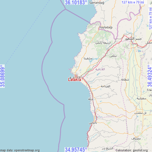
Latakia GPS coordinates[2]
35° 31' 54.048" North, 35° 47' 24.396" East
| Map corner | latitude | longitude |
|---|---|---|
| Upper-left | 36.10183°, | 35.08699° |
| Center: | 35.53168°, | 35.79011° |
| Lower-right: | 34.95745°, | 36.49324° |
| Map W x H: | 127.2×127.2 km | = 79×79mi |
| max Lat: | 37.17701° ⇑37.1% North |
| Latakia: | 35.53168° |
| min Lat: | ⇓62.9% South 32.39332° |
| min Long | Latakia | max Long |
| 35.75572° | 35.79011° | 42.14006° |
| W 0.4%⇐ | ⇒99.6% E |
Elevation
Elevation of Latakia is 29 m = 95 ft, and this is 500.1 m = 1641 ft below average elevation for this country.
| Max E: |
1640 m = 5381 ft | 98.6% |
| Avg. | 529.1 m = 1736 ft | |
| Latakia | 29 m = 95 ft | |
Min E: |
4 m = 13 ft | 1.4% |
See also: Latakia elevation on elevation.city.
Geographical zone
Latakia is located in North temperate zone (between Tropic of Cancer and the Arctic Circle). Distance of this Northern Tropic circle is 1344.8 km =835.6 mi to South.| Distance of | km | miles | from Latakia |
|---|---|---|---|
| North Pole | 6056.3 | 3763.2 | to North |
| Arctic Circle | 3450.4 | 2144 | to North |
| Tropic Cancer | 1344.8 | 835.6 | to South |
| Equator | 3950.8 | 2454.9 | to South |


Nearby cities:
15 places around Latakia: (largest is in red/bold)
• Al Bahlūlīyah
19.3 km =12 mi,  52°
52°
• Al Fākhūrah
20.2 km =12.6 mi,  100°
100°
• Al Hinādī
7.9 km =4.9 mi,  105°
105°
• Al Muzayri‘ah
25.3 km =15.7 mi,  89°
89°
• Al Qardāḩah
25.7 km =16 mi, 108°
• Al Quţaylibīyah
33.6 km =20.9 mi,  142°
142°
• Al Ḩaffah
22.9 km =14.2 mi,  71°
71°
• Jablah
22.6 km =14 mi,  146°
146°
• Jawbat Burghāl
35.1 km =21.8 mi, 97°
• Qasţal Ma‘āf
35.7 km =22.2 mi,  24°
24°
• Ḩarf al Musaytirah
35 km =21.7 mi,  117°
117°
• ‘Ayn Shiqāq
26.6 km =16.5 mi,  125°
125°
• ‘Ayn al Bayḑā
16.4 km =10.2 mi,  32°
32°
• ‘Ayn ash Sharqīyah
35.8 km =22.2 mi, 128°
• ‘Ayn at Tīnah
28.4 km =17.6 mi,  82°
82°
In other languages:
- In France: Lattaquié
- In Italian: Latakia, Laodicea
- In Russian: Латакия
- In Chinese: 拉塔基亚
Sources, notices
• [Note1] Compared only with cities in Syria existing in our database
• [Src1] Map data: © OpenStreetMap contributors (CC-BY-SA)
• [Src2] Other city data from geonames.org with taken over terms of usage.
• [Src3] Geographical zone / Annual Mean Temperature by Robert A. Rohde @ Wikipedia
