Nakhon Nayok geodata
Nakhon Nayok is a seat of a first-order administrative division; located in Thailand in Asia/Bangkok (GMT+7) time zone. With population of 21,309 people, there are 150 cities with bigger population in this country. Compared to other cities in Thailand, 62.7% of cities are located further ↑North; 57.7% of cities are located further ←West and 80.8% of cities have higher elevation than Nakhon Nayok. Note1


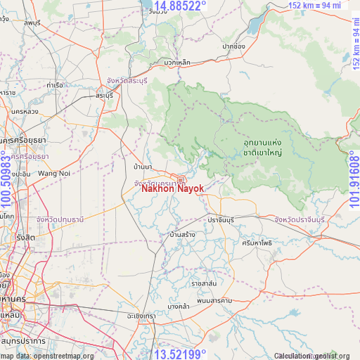
Nakhon Nayok GPS coordinates[2]
14° 12' 16.668" North, 101° 12' 46.62" East
| Map corner | latitude | longitude |
|---|---|---|
| Upper-left | 14.88522°, | 100.50983° |
| Center: | 14.20463°, | 101.21295° |
| Lower-right: | 13.52199°, | 101.91608° |
| Map W x H: | 151.6×151.6 km | = 94.2×94.2mi |
| max Lat: | 20.43353° ⇑62.7% North |
| Nakhon Nayok: | 14.20463° |
| min Lat: | ⇓37.3% South 5.77434° |
| min Long | Nakhon Nayok | max Long |
| 97.93288° | 101.21295° | 105.49506° |
| W 57.7%⇐ | ⇒42.3% E |
Elevation
Elevation of Nakhon Nayok is 12 m = 39 ft, and this is 113.5 m = 372 ft below average elevation for this country.
| Max E: |
1011 m = 3317 ft | 80.8% |
| Avg. | 125.5 m = 412 ft | |
| Nakhon Nayok | 12 m = 39 ft | |
Min E: |
1 m = 3 ft | 19.2% |
See also: Thailand elevation on elevation.city.
Geographical zone
Nakhon Nayok is located in North Torrid zone (between Equator and Tropic of Cancer). Distance of this Northern Tropic circle is 1026.5 km =637.8 mi to North.| Distance of | km | miles | from Nakhon Nayok |
|---|---|---|---|
| North Pole | 8427.7 | 5236.7 | to North |
| Arctic Circle | 5821.8 | 3617.5 | to North |
| Tropic Cancer | 1026.5 | 637.8 | to North |
| Equator | 1579.4 | 981.4 | to South |


Nearby cities:
15 places around Nakhon Nayok: (largest is in red/bold)
• Ban Na
16.6 km =10.3 mi,  292°
292°
• Ban Sang
23.3 km =14.5 mi,  177°
177°
• Bang Nam Priao
43.3 km =26.9 mi,  203°
203°
• Khlong Khuean
46.3 km =28.8 mi,  186°
186°
• Nong Khae
40.2 km =25 mi, 292°
• Nong Suea
42.5 km =26.4 mi,  259°
259°
• Ongkharak
24.4 km =15.2 mi,  247°
247°
• Pak Phli
7.6 km =4.7 mi,  127°
127°
• Prachamtakham
36.1 km =22.4 mi,  115°
115°
• Prachantakham
36.1 km =22.4 mi, 115°
• Prachin Buri
24 km =14.9 mi,  135°
135°
• Ratchasan
47.6 km =29.6 mi,  171°
171°
• Si Maha Phot
41.9 km =26 mi, 129°
• Si Mahosot
40.9 km =25.4 mi,  149°
149°
• Wihan Daeng
28.8 km =17.9 mi,  303°
303°
Sources, notices
• [Note1] Compared only with cities in Thailand existing in our database
• [Src1] Map data: © OpenStreetMap contributors (CC-BY-SA)
• [Src2] Other city data from geonames.org with taken over terms of usage.
• [Src3] Geographical zone / Annual Mean Temperature by Robert A. Rohde @ Wikipedia
