Wihan Daeng geodata
Wihan Daeng (Sara Buri) is a seat of a second-order administrative division; located in Thailand in Asia/Bangkok (GMT+7) time zone. In our database, there are 331 cities with bigger population. Compared to other cities in Thailand, 61.6% of cities are located further ↑North; 53.9% of cities are located further ←West and 85.9% of cities have higher elevation than Wihan Daeng. Note1


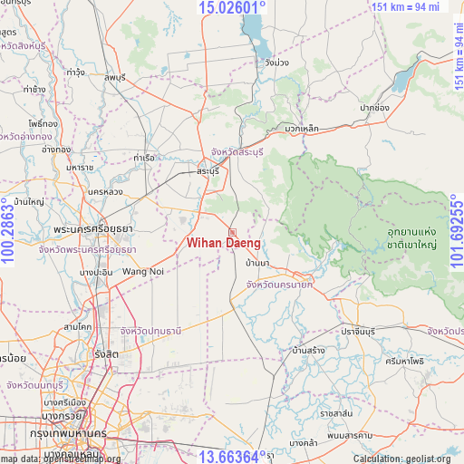
Wihan Daeng GPS coordinates[2]
14° 20' 45.096" North, 100° 59' 21.912" East
| Map corner | latitude | longitude |
|---|---|---|
| Upper-left | 15.02601°, | 100.2863° |
| Center: | 14.34586°, | 100.98942° |
| Lower-right: | 13.66364°, | 101.69255° |
| Map W x H: | 151.5×151.5 km | = 94.1×94.1mi |
| max Lat: | 20.43353° ⇑61.6% North |
| Wihan Daeng: | 14.34586° |
| min Lat: | ⇓38.4% South 5.77434° |
| min Long | Wihan Daeng | max Long |
| 97.93288° | 100.98942° | 105.49506° |
| W 53.9%⇐ | ⇒46.1% E |
Elevation
Elevation of Wihan Daeng is 10 m = 33 ft, and this is 115.5 m = 379 ft below average elevation for this country.
| Max E: |
1011 m = 3317 ft | 85.9% |
| Avg. | 125.5 m = 412 ft | |
| Wihan Daeng | 10 m = 33 ft | |
Min E: |
1 m = 3 ft | 14.1% |
See also: Thailand elevation on elevation.city.
Geographical zone
Wihan Daeng is located in North Torrid zone (between Equator and Tropic of Cancer). Distance of this Northern Tropic circle is 1010.8 km =628.1 mi to North.| Distance of | km | miles | from Wihan Daeng |
|---|---|---|---|
| North Pole | 8412 | 5227 | to North |
| Arctic Circle | 5806.1 | 3607.7 | to North |
| Tropic Cancer | 1010.8 | 628.1 | to North |
| Equator | 1595.1 | 991.1 | to South |


Nearby cities:
15 places around Wihan Daeng: (largest is in red/bold)
• Ban Na
12.8 km =8 mi,  136°
136°
• Chaloem Phra Kiat
30.8 km =19.1 mi,  343°
343°
• Kaeng Khoi
26.7 km =16.6 mi,  1°
1°
• Nakhon Nayok
28.8 km =17.9 mi,  123°
123°
• Nong Khae
13.2 km =8.2 mi,  267°
267°
• Nong Saeng
27.4 km =17 mi,  306°
306°
• Nong Suea
29.4 km =18.3 mi,  217°
217°
• Ongkharak
25 km =15.5 mi,  176°
176°
• Pak Phli
36.3 km =22.6 mi, 124°
• Phachi
30.4 km =18.9 mi,  292°
292°
• Sao Hai
27.6 km =17.1 mi,  325°
325°
• Saraburi
22.3 km =13.9 mi, 339°
• Tha Ruea
37.6 km =23.4 mi, 310°
• Uthai
34.2 km =21.3 mi, 273°
• Wang Noi
32.3 km =20.1 mi,  245°
245°
Sources, notices
• [Note1] Compared only with cities in Thailand existing in our database
• [Src1] Map data: © OpenStreetMap contributors (CC-BY-SA)
• [Src2] Other city data from geonames.org with taken over terms of usage.
• [Src3] Geographical zone / Annual Mean Temperature by Robert A. Rohde @ Wikipedia
