Betong geodata
Betong (Yala) is a seat of a second-order administrative division; located in Thailand in Asia/Bangkok (GMT+7) time zone. With population of 29,604 people, there are 108 cities with bigger population in this country. Compared to other cities in Thailand, 100% of cities are located further ↑North; 55.6% of cities are located further ←West and 89.6% of cities have lower elevation than Betong. Note1


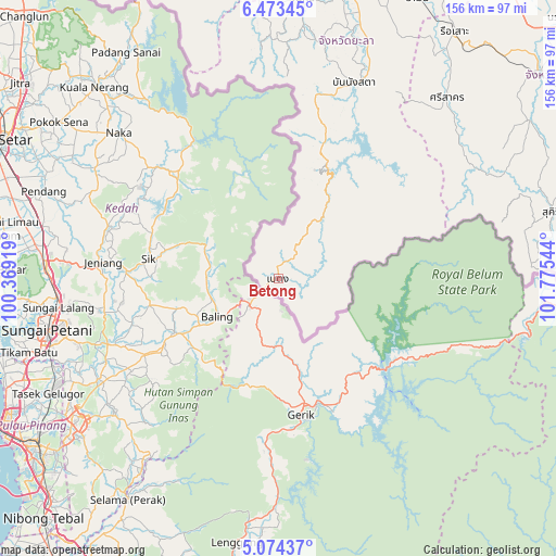
Betong GPS coordinates[2]
5° 46' 27.624" North, 101° 4' 20.316" East
| Map corner | latitude | longitude |
|---|---|---|
| Upper-left | 6.47345°, | 100.36919° |
| Center: | 5.77434°, | 101.07231° |
| Lower-right: | 5.07437°, | 101.77544° |
| Map W x H: | 155.6×155.6 km | = 96.7×96.7mi |
| max Lat: | 20.43353° ⇑100% North |
| Betong: | 5.77434° |
| min Lat: | ⇓0% South 5.77434° |
| min Long | Betong | max Long |
| 97.93288° | 101.07231° | 105.49506° |
| W 55.6%⇐ | ⇒44.4% E |
Elevation
Elevation of Betong is 269 m = 883 ft, and this is 143.5 m = 471 ft above average elevation for this country.
| Max E: |
1011 m = 3317 ft | 10.4% |
| Betong | 269 m 883 ft | |
| Avg. | 125.5 m = 412 ft | |
Min E: |
1 m = 3 ft | 89.6% |
See also: Thailand elevation on elevation.city.
Geographical zone
Betong is located in North Torrid zone (between Equator and Tropic of Cancer). Distance of Equator is 642 km =398.9 mi to South.| Distance of | km | miles | from Betong |
|---|---|---|---|
| North Pole | 9365 | 5819.1 | to North |
| Arctic Circle | 6759.1 | 4199.9 | to North |
| Tropic Cancer | 1963.9 | 1220.3 | to North |
| Equator | 642 | 398.9 | to South |


Nearby cities:
15 places around Betong: (largest is in red/bold)
• Ban Nang Sata
58.7 km =36.5 mi,  21°
21°
• Ban Su-ngai Pa Di
94.4 km =58.7 mi,  69°
69°
• Chanae
77.6 km =48.2 mi,  62°
62°
• Ka Bang
71.3 km =44.3 mi,  358°
358°
• Krong Pi Nang
74.2 km =46.1 mi, 17°
• Ra-ngae
92.9 km =57.7 mi,  51°
51°
• Raman
87.4 km =54.3 mi,  26°
26°
• Rueso
84.7 km =52.6 mi,  35°
35°
• Saba Yoi
94.7 km =58.8 mi,  351°
351°
• Si Sakhon
69.5 km =43.2 mi, 42°
• Sukhirin
79.4 km =49.3 mi,  76°
76°
• Than To
45.3 km =28.1 mi, 15°
• Waeng
91.4 km =56.8 mi, 79°
• Yaha
78.7 km =48.9 mi,  4°
4°
• Yala
88.2 km =54.8 mi, 15°
Sources, notices
• [Note1] Compared only with cities in Thailand existing in our database
• [Src1] Map data: © OpenStreetMap contributors (CC-BY-SA)
• [Src2] Other city data from geonames.org with taken over terms of usage.
• [Src3] Geographical zone / Annual Mean Temperature by Robert A. Rohde @ Wikipedia
