Bang Yai geodata
Bang Yai (Nonthaburi) is a populated place; located in Thailand in Asia/Bangkok (GMT+7) time zone. With population of 14,012 people, there are 236 cities with bigger population in this country. Compared to other cities in Thailand, 66.8% of cities are located further ↑North; 62.4% of cities are located further →East and 98% of cities have higher elevation than Bang Yai. Note1


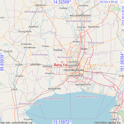
Bang Yai GPS coordinates[2]
13° 50' 36.276" North, 100° 21' 45.036" East
| Map corner | latitude | longitude |
|---|---|---|
| Upper-left | 14.52509°, | 99.65939° |
| Center: | 13.84341°, | 100.36251° |
| Lower-right: | 13.15972°, | 101.06564° |
| Map W x H: | 151.8×151.8 km | = 94.3×94.3mi |
| max Lat: | 20.43353° ⇑66.8% North |
| Bang Yai: | 13.84341° |
| min Lat: | ⇓33.2% South 5.77434° |
| min Long | Bang Yai | max Long |
| 97.93288° | 100.36251° | 105.49506° |
| W 37.6%⇐ | ⇒62.4% E |
Elevation
Elevation of Bang Yai is 5 m = 16 ft, and this is 120.5 m = 395 ft below average elevation for this country.
| Max E: |
1011 m = 3317 ft | 98% |
| Avg. | 125.5 m = 412 ft | |
| Bang Yai | 5 m = 16 ft | |
Min E: |
1 m = 3 ft | 2% |
See also: Thailand elevation on elevation.city.
Geographical zone
Bang Yai is located in North Torrid zone (between Equator and Tropic of Cancer). Distance of this Northern Tropic circle is 1066.7 km =662.8 mi to North.| Distance of | km | miles | from Bang Yai |
|---|---|---|---|
| North Pole | 8467.8 | 5261.6 | to North |
| Arctic Circle | 5861.9 | 3642.4 | to North |
| Tropic Cancer | 1066.7 | 662.8 | to North |
| Equator | 1539.2 | 956.4 | to South |


Nearby cities:
15 places around Bang Yai: (largest is in red/bold)
• Bang Bua Thong
10.6 km =6.6 mi,  38°
38°
• Bang Khae
17.5 km =10.9 mi,  164°
164°
• Bang Kruai
12.7 km =7.9 mi,  109°
109°
• Bangkok
18 km =11.2 mi,  123°
123°
• Bangkok Noi
15.4 km =9.6 mi,  125°
125°
• Bangkok Yai
18.1 km =11.2 mi,  137°
137°
• Mueang Nonthaburi
16.6 km =10.3 mi,  83°
83°
• Nong Khaem
15.4 km =9.6 mi,  185°
185°
• Pak Kret
16.6 km =10.3 mi,  62°
62°
• Phasi Charoen
16.4 km =10.2 mi,  150°
150°
• Phra Nakhon
17.1 km =10.6 mi, 120°
• Sai Noi
16 km =9.9 mi,  340°
340°
• Salaya
6.4 km =4 mi,  224°
224°
• Taling Chan
12.6 km =7.8 mi, 125°
• Thawi Watthana
6.9 km =4.3 mi,  207°
207°
Sources, notices
• [Note1] Compared only with cities in Thailand existing in our database
• [Src1] Map data: © OpenStreetMap contributors (CC-BY-SA)
• [Src2] Other city data from geonames.org with taken over terms of usage.
• [Src3] Geographical zone / Annual Mean Temperature by Robert A. Rohde @ Wikipedia
