Bangkok geodata
Bangkok is a capital of a political entity; located in Thailand in Asia/Bangkok (GMT+7) time zone. With population of 5,104,476 people, there are 0 cities with bigger population in this country. Compared to other cities in Thailand, 69.9% of cities are located further ↑North; 58.2% of cities are located further →East and 80.8% of cities have higher elevation than Bangkok. Note1


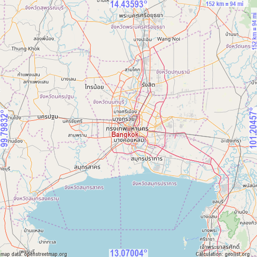
Bangkok GPS coordinates[2]
13° 45' 14.328" North, 100° 30' 5.184" East
| Map corner | latitude | longitude |
|---|---|---|
| Upper-left | 14.43593°, | 99.79832° |
| Center: | 13.75398°, | 100.50144° |
| Lower-right: | 13.07004°, | 101.20457° |
| Map W x H: | 151.9×151.9 km | = 94.4×94.4mi |
| max Lat: | 20.43353° ⇑69.9% North |
| Bangkok: | 13.75398° |
| min Lat: | ⇓30.1% South 5.77434° |
| min Long | Bangkok | max Long |
| 97.93288° | 100.50144° | 105.49506° |
| W 41.8%⇐ | ⇒58.2% E |
Elevation
Elevation of Bangkok is 12 m = 39 ft, and this is 113.5 m = 372 ft below average elevation for this country.
| Max E: |
1011 m = 3317 ft | 80.8% |
| Avg. | 125.5 m = 412 ft | |
| Bangkok | 12 m = 39 ft | |
Min E: |
1 m = 3 ft | 19.2% |
See also: Bangkok elevation on elevation.city.
Geographical zone
Bangkok is located in North Torrid zone (between Equator and Tropic of Cancer). Distance of this Northern Tropic circle is 1076.6 km =669 mi to North.| Distance of | km | miles | from Bangkok |
|---|---|---|---|
| North Pole | 8477.8 | 5267.9 | to North |
| Arctic Circle | 5871.9 | 3648.6 | to North |
| Tropic Cancer | 1076.6 | 669 | to North |
| Equator | 1529.3 | 950.3 | to South |


Nearby cities:
15 places around Bangkok: (largest is in red/bold)
• Bang Rak
3.6 km =2.2 mi,  137°
137°
• Bangkok Noi
2.7 km =1.7 mi,  290°
290°
• Bangkok Yai
4.4 km =2.7 mi,  218°
218°
• Din Daeng
5.8 km =3.6 mi,  72°
72°
• Dusit
3.3 km =2.1 mi,  37°
37°
• Khlong San
2.7 km =1.7 mi,  162°
162°
• Pathum Wan
3.1 km =1.9 mi,  128°
128°
• Phaya Thai
5.3 km =3.3 mi,  56°
56°
• Phra Nakhon
1.3 km =0.8 mi,  346°
346°
• Pom Prap Sattru Phai
1.4 km =0.9 mi, 69°
• Ratchathewi
3.5 km =2.2 mi,  80°
80°
• Samphanthawong
2.9 km =1.8 mi,  151°
151°
• Sathon
5.7 km =3.5 mi, 152°
• Taling Chan
5.5 km =3.4 mi,  297°
297°
• Thon Buri
3.7 km =2.3 mi,  208°
208°
Sources, notices
• [Note1] Compared only with cities in Thailand existing in our database
• [Src1] Map data: © OpenStreetMap contributors (CC-BY-SA)
• [Src2] Other city data from geonames.org with taken over terms of usage.
• [Src3] Geographical zone / Annual Mean Temperature by Robert A. Rohde @ Wikipedia
