Mueang Nonthaburi geodata
Mueang Nonthaburi (Nonthaburi) is a seat of a first-order administrative division; located in Thailand in Asia/Bangkok (GMT+7) time zone. With population of 291,555 people, there are 2 cities with bigger population in this country. Compared to other cities in Thailand, 66.4% of cities are located further ↑North; 57.3% of cities are located further →East and 100% of cities have higher elevation than Mueang Nonthaburi. Note1


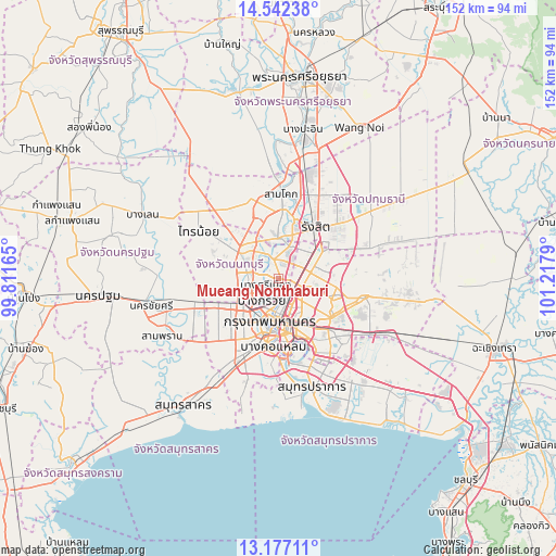
Mueang Nonthaburi GPS coordinates[2]
13° 51' 38.7" North, 100° 30' 53.172" East
| Map corner | latitude | longitude |
|---|---|---|
| Upper-left | 14.54238°, | 99.81165° |
| Center: | 13.86075°, | 100.51477° |
| Lower-right: | 13.17711°, | 101.2179° |
| Map W x H: | 151.8×151.8 km | = 94.3×94.3mi |
| max Lat: | 20.43353° ⇑66.4% North |
| Mueang Nonthaburi: | 13.86075° |
| min Lat: | ⇓33.6% South 5.77434° |
| min Long | Mueang Nonthabu | max Long |
| 97.93288° | 100.51477° | 105.49506° |
| W 42.7%⇐ | ⇒57.3% E |
Elevation
Elevation of Mueang Nonthaburi is 1 m = 3 ft, and this is 124.5 m = 408 ft below average elevation for this country.
| Max E: |
1011 m = 3317 ft | 100% |
| Avg. | 125.5 m = 412 ft | |
| Mueang Nonthaburi | 1 m = 3 ft | |
Min E: |
1 m = 3 ft | 0% |
See also: Mueang Nonthaburi elevation on elevation.city.
Geographical zone
Mueang Nonthaburi is located in North Torrid zone (between Equator and Tropic of Cancer). Distance of this Northern Tropic circle is 1064.7 km =661.6 mi to North.| Distance of | km | miles | from Mueang Nonthaburi |
|---|---|---|---|
| North Pole | 8465.9 | 5260.5 | to North |
| Arctic Circle | 5860 | 3641.2 | to North |
| Tropic Cancer | 1064.7 | 661.6 | to North |
| Equator | 1541.2 | 957.7 | to South |


Nearby cities:
15 places around Mueang Nonthaburi: (largest is in red/bold)
• Bang Bua Thong
11.7 km =7.3 mi,  302°
302°
• Bang Kruai
7.7 km =4.8 mi,  216°
216°
• Bang Sue
6.1 km =3.8 mi,  156°
156°
• Bangkok Noi
11.6 km =7.2 mi,  200°
200°
• Chatuchak
6 km =3.7 mi,  126°
126°
• Din Daeng
10.9 km =6.8 mi, 157°
• Don Mueang
10 km =6.2 mi,  53°
53°
• Dusit
9.3 km =5.8 mi,  176°
176°
• Huai Khwang
11.6 km =7.2 mi,  143°
143°
• Pak Kret
6.1 km =3.8 mi,  343°
343°
• Phaya Thai
9.5 km =5.9 mi, 161°
• Phra Nakhon
10.8 km =6.7 mi,  189°
189°
• Pom Prap Sattru Phai
11.4 km =7.1 mi, 180°
• Ratchathewi
11.5 km =7.1 mi,  169°
169°
• Taling Chan
11.2 km =7 mi,  213°
213°
Sources, notices
• [Note1] Compared only with cities in Thailand existing in our database
• [Src1] Map data: © OpenStreetMap contributors (CC-BY-SA)
• [Src2] Other city data from geonames.org with taken over terms of usage.
• [Src3] Geographical zone / Annual Mean Temperature by Robert A. Rohde @ Wikipedia
