Ban Chang geodata
Ban Chang (Rayong) is a seat of a second-order administrative division; located in Thailand in Asia/Bangkok (GMT+7) time zone. With population of 28,204 people, there are 117 cities with bigger population in this country. Compared to other cities in Thailand, 79.5% of cities are located further ↑North; 54.9% of cities are located further ←West and 58.2% of cities have higher elevation than Ban Chang. Note1


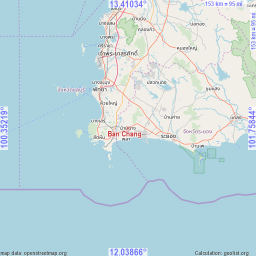
Ban Chang GPS coordinates[2]
12° 43' 31.548" North, 101° 3' 19.116" East
| Map corner | latitude | longitude |
|---|---|---|
| Upper-left | 13.41034°, | 100.35219° |
| Center: | 12.72543°, | 101.05531° |
| Lower-right: | 12.03866°, | 101.75844° |
| Map W x H: | 152.5×152.5 km | = 94.8×94.8mi |
| max Lat: | 20.43353° ⇑79.5% North |
| Ban Chang: | 12.72543° |
| min Lat: | ⇓20.5% South 5.77434° |
| min Long | Ban Chang | max Long |
| 97.93288° | 101.05531° | 105.49506° |
| W 54.9%⇐ | ⇒45.1% E |
Elevation
Elevation of Ban Chang is 49 m = 161 ft, and this is 76.5 m = 251 ft below average elevation for this country.
| Max E: |
1011 m = 3317 ft | 58.2% |
| Avg. | 125.5 m = 412 ft | |
| Ban Chang | 49 m = 161 ft | |
Min E: |
1 m = 3 ft | 41.8% |
See also: Thailand elevation on elevation.city.
Geographical zone
Ban Chang is located in North Torrid zone (between Equator and Tropic of Cancer). Distance of this Northern Tropic circle is 1191 km =740.1 mi to North.| Distance of | km | miles | from Ban Chang |
|---|---|---|---|
| North Pole | 8592.1 | 5338.9 | to North |
| Arctic Circle | 5986.2 | 3719.7 | to North |
| Tropic Cancer | 1191 | 740.1 | to North |
| Equator | 1414.9 | 879.2 | to South |


Nearby cities:
15 places around Ban Chang: (largest is in red/bold)
• Ban Khai
26.9 km =16.7 mi,  76°
76°
• Ban Ko Lan
36.5 km =22.7 mi,  307°
307°
• Ban Phe
42.9 km =26.7 mi,  104°
104°
• Ban Talat Bueng
38.9 km =24.2 mi,  351°
351°
• Bang Lamung
38.3 km =23.8 mi,  339°
339°
• Ko Si Chang
55.8 km =34.7 mi,  330°
330°
• Na Kluea
31.4 km =19.5 mi, 326°
• Nikhom Phattana
19.6 km =12.2 mi,  54°
54°
• Nong Yai
58.8 km =36.5 mi,  35°
35°
• Pattaya
29.7 km =18.5 mi,  321°
321°
• Pluak Daeng
32.3 km =20.1 mi,  32°
32°
• Rayong
22.5 km =14 mi, 102°
• Sattahip
18 km =11.2 mi,  248°
248°
• Si Racha
51.6 km =32.1 mi, 344°
• Wang Chan
55.9 km =34.7 mi,  65°
65°
Sources, notices
• [Note1] Compared only with cities in Thailand existing in our database
• [Src1] Map data: © OpenStreetMap contributors (CC-BY-SA)
• [Src2] Other city data from geonames.org with taken over terms of usage.
• [Src3] Geographical zone / Annual Mean Temperature by Robert A. Rohde @ Wikipedia
