Wang Chan geodata
Wang Chan (Rayong) is a seat of a second-order administrative division; located in Thailand in Asia/Bangkok (GMT+7) time zone. In our database, there are 331 cities with bigger population. Compared to other cities in Thailand, 78.4% of cities are located further ↑North; 61.8% of cities are located further ←West and 61.5% of cities have higher elevation than Wang Chan. Note1


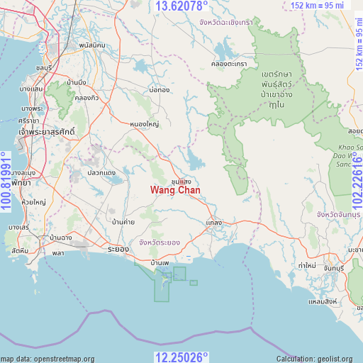
Wang Chan GPS coordinates[2]
12° 56' 11.256" North, 101° 31' 22.908" East
| Map corner | latitude | longitude |
|---|---|---|
| Upper-left | 13.62078°, | 100.81991° |
| Center: | 12.93646°, | 101.52303° |
| Lower-right: | 12.25026°, | 102.22616° |
| Map W x H: | 152.4×152.4 km | = 94.7×94.7mi |
| max Lat: | 20.43353° ⇑78.4% North |
| Wang Chan: | 12.93646° |
| min Lat: | ⇓21.6% South 5.77434° |
| min Long | Wang Chan | max Long |
| 97.93288° | 101.52303° | 105.49506° |
| W 61.8%⇐ | ⇒38.2% E |
Elevation
Elevation of Wang Chan is 41 m = 135 ft, and this is 84.5 m = 277 ft below average elevation for this country.
| Max E: |
1011 m = 3317 ft | 61.5% |
| Avg. | 125.5 m = 412 ft | |
| Wang Chan | 41 m = 135 ft | |
Min E: |
1 m = 3 ft | 38.5% |
See also: Thailand elevation on elevation.city.
Geographical zone
Wang Chan is located in North Torrid zone (between Equator and Tropic of Cancer). Distance of this Northern Tropic circle is 1167.5 km =725.5 mi to North.| Distance of | km | miles | from Wang Chan |
|---|---|---|---|
| North Pole | 8568.7 | 5324.3 | to North |
| Arctic Circle | 5962.8 | 3705.1 | to North |
| Tropic Cancer | 1167.5 | 725.5 | to North |
| Equator | 1438.4 | 893.8 | to South |


Nearby cities:
15 places around Wang Chan: (largest is in red/bold)
• Ban Chang
55.9 km =34.7 mi,  245°
245°
• Ban Khai
29.9 km =18.6 mi,  235°
235°
• Ban Phe
35.5 km =22.1 mi,  195°
195°
• Ban Talat Bueng
58.3 km =36.2 mi,  284°
284°
• Bo Thong
39 km =24.2 mi,  346°
346°
• Kaeng Hang Maeo
42.3 km =26.3 mi,  79°
79°
• Khao Chamao
18.1 km =11.2 mi, 75°
• Klaeng
22.1 km =13.7 mi,  142°
142°
• Ko Chan
57.2 km =35.5 mi,  339°
339°
• Na Yai Am
36.8 km =22.9 mi,  117°
117°
• Nikhom Phattana
36.8 km =22.9 mi, 250°
• Nong Yai
29.3 km =18.2 mi,  326°
326°
• Pluak Daeng
33.6 km =20.9 mi, 276°
• Rayong
40.4 km =25.1 mi,  225°
225°
• Tha Takiap
57.4 km =35.7 mi,  9°
9°
Sources, notices
• [Note1] Compared only with cities in Thailand existing in our database
• [Src1] Map data: © OpenStreetMap contributors (CC-BY-SA)
• [Src2] Other city data from geonames.org with taken over terms of usage.
• [Src3] Geographical zone / Annual Mean Temperature by Robert A. Rohde @ Wikipedia
