Yeşilyurt geodata
Yeşilyurt (Şırnak) is a populated place; located in Turkey in Europe/Istanbul (GMT+3) time zone. With population of 574 people, there are 1269 cities with bigger population in this country. Compared to other cities in Turkey, 80.1% of cities are located further ↑North; 91.6% of cities are located further ←West and 58.6% of cities have higher elevation than Yeşilyurt. Note1


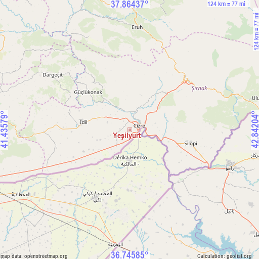
Yeşilyurt GPS coordinates[2]
37° 18' 25.884" North, 42° 8' 20.076" East
| Map corner | latitude | longitude |
|---|---|---|
| Upper-left | 37.86437°, | 41.43579° |
| Center: | 37.30719°, | 42.13891° |
| Lower-right: | 36.74585°, | 42.84204° |
| Map W x H: | 124.4×124.4 km | = 77.3×77.3mi |
| max Lat: | 42.02683° ⇑80.1% North |
| Yeşilyurt: | 37.30719° |
| min Lat: | ⇓19.9% South 35.9025° |
| min Long | Yeşilyurt | max Long |
| 25.90902° | 42.13891° | 44.60099° |
| W 91.6%⇐ | ⇒8.4% E |
Elevation
Elevation of Yeşilyurt is 527 m = 1729 ft, and this is 190.4 m = 625 ft below average elevation for this country.
| Max E: |
2682 m = 8799 ft | 58.6% |
| Avg. | 717.4 m = 2354 ft | |
| Yeşilyurt | 527 m = 1729 ft | |
Min E: |
0 m = 0 ft | 41.4% |
See also: Turkey elevation on elevation.city.
Geographical zone
Yeşilyurt is located in North temperate zone (between Tropic of Cancer and the Arctic Circle). Distance of this Northern Tropic circle is 1542.3 km =958.3 mi to South.| Distance of | km | miles | from Yeşilyurt |
|---|---|---|---|
| North Pole | 5858.9 | 3640.6 | to North |
| Arctic Circle | 3253 | 2021.3 | to North |
| Tropic Cancer | 1542.3 | 958.3 | to South |
| Equator | 4148.2 | 2577.6 | to South |


Nearby cities:
15 places around Yeşilyurt: (largest is in red/bold)
• Barim
18.2 km =11.3 mi,  258°
258°
• Bozalan
11.3 km =7 mi,  77°
77°
• Cibri
5 km =3.1 mi,  226°
226°
• Cizre
4.8 km =3 mi,  57°
57°
• Dicle
6.7 km =4.2 mi,  252°
252°
• Doruklu
18.3 km =11.4 mi,  108°
108°
• Düzova
6.9 km =4.3 mi,  319°
319°
• Katran
6.6 km =4.1 mi,  203°
203°
• Korucu
10.9 km =6.8 mi,  221°
221°
• Kızılsu
17.1 km =10.6 mi,  17°
17°
• Ozan
15 km =9.3 mi, 250°
• Razvaliny Ayinvan
17.5 km =10.9 mi,  99°
99°
• Sulak
1.4 km =0.9 mi,  189°
189°
• Tililan
11.9 km =7.4 mi,  308°
308°
• Yavşan
18.1 km =11.2 mi, 228°
Sources, notices
• [Note1] Compared only with cities in Turkey existing in our database
• [Src1] Map data: © OpenStreetMap contributors (CC-BY-SA)
• [Src2] Other city data from geonames.org with taken over terms of usage.
• [Src3] Geographical zone / Annual Mean Temperature by Robert A. Rohde @ Wikipedia
