Uzungeçit geodata
Uzungeçit (Şırnak) is a populated place; located in Turkey in Europe/Istanbul (GMT+3) time zone. With population of 3,993 people, there are 781 cities with bigger population in this country. Compared to other cities in Turkey, 75% of cities are located further ↑North; 96.5% of cities are located further ←West and 92% of cities have lower elevation than Uzungeçit. Note1


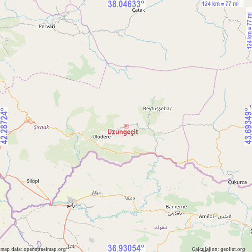
Uzungeçit GPS coordinates[2]
37° 29' 25.872" North, 42° 59' 25.296" East
| Map corner | latitude | longitude |
|---|---|---|
| Upper-left | 38.04633°, | 42.28724° |
| Center: | 37.49052°, | 42.99036° |
| Lower-right: | 36.93054°, | 43.69349° |
| Map W x H: | 124.1×124.1 km | = 77.1×77.1mi |
| max Lat: | 42.02683° ⇑75% North |
| Uzungeçit: | 37.49052° |
| min Lat: | ⇓25% South 35.9025° |
| min Long | Uzungeçit | max Long |
| 25.90902° | 42.99036° | 44.60099° |
| W 96.5%⇐ | ⇒3.5% E |
Elevation
Elevation of Uzungeçit is 1541 m = 5056 ft, and this is 823.6 m = 2702 ft above average elevation for this country.
| Max E: |
2682 m = 8799 ft | 8% |
| Uzungeçit | 1541 m 5056 ft | |
| Avg. | 717.4 m = 2354 ft | |
Min E: |
0 m = 0 ft | 92% |
See also: Turkey elevation on elevation.city.
Geographical zone
Uzungeçit is located in North temperate zone (between Tropic of Cancer and the Arctic Circle). Distance of this Northern Tropic circle is 1562.6 km =971 mi to South.| Distance of | km | miles | from Uzungeçit |
|---|---|---|---|
| North Pole | 5838.5 | 3627.9 | to North |
| Arctic Circle | 3232.6 | 2008.6 | to North |
| Tropic Cancer | 1562.6 | 971 | to South |
| Equator | 4168.6 | 2590.2 | to South |


Nearby cities:
15 places around Uzungeçit: (largest is in red/bold)
• Aşağıdere
11.7 km =7.3 mi,  77°
77°
• Ballı
15.8 km =9.8 mi,  237°
237°
• Başaran
12.4 km =7.7 mi,  97°
97°
• Becuh
11 km =6.8 mi,  180°
180°
• Beytüşşebap
17.5 km =10.9 mi,  62°
62°
• Bolağaç
4.3 km =2.7 mi, 77°
• Boğazören
4.4 km =2.7 mi,  20°
20°
• Dağdibi
14.5 km =9 mi,  137°
137°
• Hilal
18.1 km =11.2 mi,  264°
264°
• Ortabağ
12.6 km =7.8 mi,  214°
214°
• Ortasu
13.9 km =8.6 mi,  191°
191°
• Pirinçli
5.3 km =3.3 mi,  49°
49°
• Taşdelen
16.4 km =10.2 mi,  220°
220°
• Uludere
13.4 km =8.3 mi,  245°
245°
• Yemişli
15.7 km =9.8 mi,  150°
150°
Sources, notices
• [Note1] Compared only with cities in Turkey existing in our database
• [Src1] Map data: © OpenStreetMap contributors (CC-BY-SA)
• [Src2] Other city data from geonames.org with taken over terms of usage.
• [Src3] Geographical zone / Annual Mean Temperature by Robert A. Rohde @ Wikipedia
