Becuh geodata
Becuh (Şırnak) is a populated place; located in Turkey in Europe/Istanbul (GMT+3) time zone. With population of 3,372 people, there are 830 cities with bigger population in this country. Compared to other cities in Turkey, 77.8% of cities are located further ↑North; 96.5% of cities are located further ←West and 87% of cities have lower elevation than Becuh. Note1


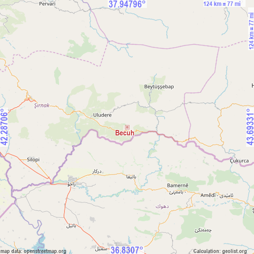
Becuh GPS coordinates[2]
37° 23' 29.076" North, 42° 59' 24.648" East
| Map corner | latitude | longitude |
|---|---|---|
| Upper-left | 37.94796°, | 42.28706° |
| Center: | 37.39141°, | 42.99018° |
| Lower-right: | 36.8307°, | 43.69331° |
| Map W x H: | 124.2×124.2 km | = 77.2×77.2mi |
| max Lat: | 42.02683° ⇑77.8% North |
| Becuh: | 37.39141° |
| min Lat: | ⇓22.2% South 35.9025° |
| min Long | Becuh | max Long |
| 25.90902° | 42.99018° | 44.60099° |
| W 96.5%⇐ | ⇒3.5% E |
Elevation
Elevation of Becuh is 1366 m = 4482 ft, and this is 648.6 m = 2128 ft above average elevation for this country.
| Max E: |
2682 m = 8799 ft | 13% |
| Becuh | 1366 m 4482 ft | |
| Avg. | 717.4 m = 2354 ft | |
Min E: |
0 m = 0 ft | 87% |
See also: Turkey elevation on elevation.city.
Geographical zone
Becuh is located in North temperate zone (between Tropic of Cancer and the Arctic Circle). Distance of this Northern Tropic circle is 1551.6 km =964.1 mi to South.| Distance of | km | miles | from Becuh |
|---|---|---|---|
| North Pole | 5849.5 | 3634.7 | to North |
| Arctic Circle | 3243.6 | 2015.5 | to North |
| Tropic Cancer | 1551.6 | 964.1 | to South |
| Equator | 4157.5 | 2583.3 | to South |


Nearby cities:
15 places around Becuh: (largest is in red/bold)
• Aşağıdere
17.7 km =11 mi,  40°
40°
• Ballı
13.5 km =8.4 mi,  280°
280°
• Bağlıca
19.6 km =12.2 mi, 283°
• Başaran
15.5 km =9.6 mi,  52°
52°
• Bolağaç
12.7 km =7.9 mi,  19°
19°
• Boğazören
15.2 km =9.4 mi,  5°
5°
• Dağdibi
9.8 km =6.1 mi,  88°
88°
• Hilal
20.3 km =12.6 mi,  297°
297°
• Ortabağ
7.1 km =4.4 mi,  274°
274°
• Ortasu
3.8 km =2.4 mi,  228°
228°
• Pirinçli
15 km =9.3 mi, 15°
• Taşdelen
10.8 km =6.7 mi,  262°
262°
• Uludere
13.3 km =8.3 mi,  294°
294°
• Uzungeçit
11 km =6.8 mi,  0°
0°
• Yemişli
8.1 km =5 mi,  109°
109°
Sources, notices
• [Note1] Compared only with cities in Turkey existing in our database
• [Src1] Map data: © OpenStreetMap contributors (CC-BY-SA)
• [Src2] Other city data from geonames.org with taken over terms of usage.
• [Src3] Geographical zone / Annual Mean Temperature by Robert A. Rohde @ Wikipedia
