Uludere geodata
Uludere (Şırnak) is a seat of a second-order administrative division; located in Turkey in Europe/Istanbul (GMT+3) time zone. With population of 8,827 people, there are 538 cities with bigger population in this country. Compared to other cities in Turkey, 76.4% of cities are located further ↑North; 96% of cities are located further ←West and 86.2% of cities have lower elevation than Uludere. Note1


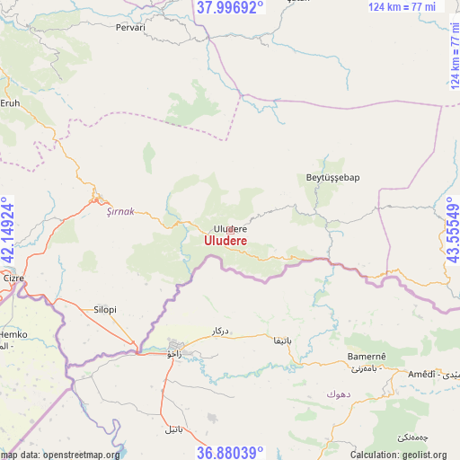
Uludere GPS coordinates[2]
37° 26' 26.664" North, 42° 51' 8.496" East
| Map corner | latitude | longitude |
|---|---|---|
| Upper-left | 37.99692°, | 42.14924° |
| Center: | 37.44074°, | 42.85236° |
| Lower-right: | 36.88039°, | 43.55549° |
| Map W x H: | 124.1×124.1 km | = 77.1×77.1mi |
| max Lat: | 42.02683° ⇑76.4% North |
| Uludere: | 37.44074° |
| min Lat: | ⇓23.6% South 35.9025° |
| min Long | Uludere | max Long |
| 25.90902° | 42.85236° | 44.60099° |
| W 96%⇐ | ⇒4% E |
Elevation
Elevation of Uludere is 1346 m = 4416 ft, and this is 628.6 m = 2062 ft above average elevation for this country.
| Max E: |
2682 m = 8799 ft | 13.8% |
| Uludere | 1346 m 4416 ft | |
| Avg. | 717.4 m = 2354 ft | |
Min E: |
0 m = 0 ft | 86.2% |
See also: Turkey elevation on elevation.city.
Geographical zone
Uludere is located in North temperate zone (between Tropic of Cancer and the Arctic Circle). Distance of this Northern Tropic circle is 1557.1 km =967.5 mi to South.| Distance of | km | miles | from Uludere |
|---|---|---|---|
| North Pole | 5844 | 3631.3 | to North |
| Arctic Circle | 3238.2 | 2012.1 | to North |
| Tropic Cancer | 1557.1 | 967.5 | to South |
| Equator | 4163 | 2586.8 | to South |


Nearby cities:
15 places around Uludere: (largest is in red/bold)
• Ballı
3.3 km =2.1 mi,  200°
200°
• Bağlıca
7 km =4.3 mi,  263°
263°
• Becuh
13.3 km =8.3 mi,  114°
114°
• Bolağaç
17.6 km =10.9 mi,  68°
68°
• Boğazören
16.8 km =10.4 mi,  54°
54°
• Dağdibi
22.6 km =14 mi,  103°
103°
• Hilal
7 km =4.3 mi,  303°
303°
• Ortabağ
7.1 km =4.4 mi,  133°
133°
• Ortasu
12.3 km =7.6 mi, 130°
• Pirinçli
18.5 km =11.5 mi,  60°
60°
• Taşdelen
7.1 km =4.4 mi,  168°
168°
• Uzungeçit
13.4 km =8.3 mi, 65°
• Yemişli
21.5 km =13.4 mi, 112°
• Çalışkan
24.5 km =15.2 mi,  229°
229°
• Şenoba
11.8 km =7.3 mi,  282°
282°
Sources, notices
• [Note1] Compared only with cities in Turkey existing in our database
• [Src1] Map data: © OpenStreetMap contributors (CC-BY-SA)
• [Src2] Other city data from geonames.org with taken over terms of usage.
• [Src3] Geographical zone / Annual Mean Temperature by Robert A. Rohde @ Wikipedia
