Seri geodata
Seri (Mardin) is a populated place; located in Turkey in Europe/Istanbul (GMT+3) time zone. With population of 1,059 people, there are 1078 cities with bigger population in this country. Compared to other cities in Turkey, 78.9% of cities are located further ↑North; 84.2% of cities are located further ←West and 65.5% of cities have lower elevation than Seri. Note1


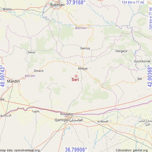
Seri GPS coordinates[2]
37° 21' 36.036" North, 41° 18' 1.98" East
| Map corner | latitude | longitude |
|---|---|---|
| Upper-left | 37.9168°, | 40.59743° |
| Center: | 37.36001°, | 41.30055° |
| Lower-right: | 36.79906°, | 42.00368° |
| Map W x H: | 124.3×124.3 km | = 77.2×77.2mi |
| max Lat: | 42.02683° ⇑78.9% North |
| Seri: | 37.36001° |
| min Lat: | ⇓21.1% South 35.9025° |
| min Long | Seri | max Long |
| 25.90902° | 41.30055° | 44.60099° |
| W 84.2%⇐ | ⇒15.8% E |
Elevation
Elevation of Seri is 967 m = 3173 ft, and this is 249.6 m = 819 ft above average elevation for this country.
| Max E: |
2682 m = 8799 ft | 34.5% |
| Seri | 967 m 3173 ft | |
| Avg. | 717.4 m = 2354 ft | |
Min E: |
0 m = 0 ft | 65.5% |
See also: Turkey elevation on elevation.city.
Geographical zone
Seri is located in North temperate zone (between Tropic of Cancer and the Arctic Circle). Distance of this Northern Tropic circle is 1548.1 km =961.9 mi to South.| Distance of | km | miles | from Seri |
|---|---|---|---|
| North Pole | 5853 | 3636.9 | to North |
| Arctic Circle | 3247.1 | 2017.7 | to North |
| Tropic Cancer | 1548.1 | 961.9 | to South |
| Equator | 4154 | 2581.2 | to South |


Nearby cities:
15 places around Seri: (largest is in red/bold)
• Acırlı
10.6 km =6.6 mi,  357°
357°
• Barıştepe
16.4 km =10.2 mi,  33°
33°
• Budaklı
4.7 km =2.9 mi,  64°
64°
• Düzoba
4.3 km =2.7 mi,  325°
325°
• Ebish
15.2 km =9.4 mi,  319°
319°
• Gelinkaya
6.9 km =4.3 mi,  336°
336°
• Kayalıpınar
7.3 km =4.5 mi,  242°
242°
• Kindirip
12 km =7.5 mi, 323°
• Kutlubey
12.4 km =7.7 mi, 241°
• Midyat
7.4 km =4.6 mi, 27°
• Sivrice
9.8 km =6.1 mi,  161°
161°
• Toptepe
11.9 km =7.4 mi,  202°
202°
• Yolbaşı
3.4 km =2.1 mi, 26°
• Çalpınar
10.2 km =6.3 mi,  273°
273°
• Çavuşlu
16.4 km =10.2 mi, 343°
Sources, notices
• [Note1] Compared only with cities in Turkey existing in our database
• [Src1] Map data: © OpenStreetMap contributors (CC-BY-SA)
• [Src2] Other city data from geonames.org with taken over terms of usage.
• [Src3] Geographical zone / Annual Mean Temperature by Robert A. Rohde @ Wikipedia
