Gelinkaya geodata
Gelinkaya (Mardin) is a populated place; located in Turkey in Europe/Istanbul (GMT+3) time zone. With population of 6,470 people, there are 633 cities with bigger population in this country. Compared to other cities in Turkey, 77.1% of cities are located further ↑North; 83.7% of cities are located further ←West and 64.4% of cities have lower elevation than Gelinkaya. Note1


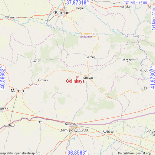
Gelinkaya GPS coordinates[2]
37° 25' 0.588" North, 41° 16' 11.784" East
| Map corner | latitude | longitude |
|---|---|---|
| Upper-left | 37.97319°, | 40.56682° |
| Center: | 37.41683°, | 41.26994° |
| Lower-right: | 36.8563°, | 41.97307° |
| Map W x H: | 124.2×124.2 km | = 77.2×77.2mi |
| max Lat: | 42.02683° ⇑77.1% North |
| Gelinkaya: | 37.41683° |
| min Lat: | ⇓22.9% South 35.9025° |
| min Long | Gelinkaya | max Long |
| 25.90902° | 41.26994° | 44.60099° |
| W 83.7%⇐ | ⇒16.3% E |
Elevation
Elevation of Gelinkaya is 949 m = 3114 ft, and this is 231.6 m = 760 ft above average elevation for this country.
| Max E: |
2682 m = 8799 ft | 35.6% |
| Gelinkaya | 949 m 3114 ft | |
| Avg. | 717.4 m = 2354 ft | |
Min E: |
0 m = 0 ft | 64.4% |
See also: Turkey elevation on elevation.city.
Geographical zone
Gelinkaya is located in North temperate zone (between Tropic of Cancer and the Arctic Circle). Distance of this Northern Tropic circle is 1554.4 km =965.9 mi to South.| Distance of | km | miles | from Gelinkaya |
|---|---|---|---|
| North Pole | 5846.7 | 3633 | to North |
| Arctic Circle | 3240.8 | 2013.7 | to North |
| Tropic Cancer | 1554.4 | 965.9 | to South |
| Equator | 4160.4 | 2585.2 | to South |


Nearby cities:
15 places around Gelinkaya: (largest is in red/bold)
• Acırlı
4.8 km =3 mi,  27°
27°
• Barıştepe
13.8 km =8.6 mi,  57°
57°
• Budaklı
8.1 km =5 mi,  121°
121°
• Düzoba
2.8 km =1.7 mi,  174°
174°
• Ebish
8.9 km =5.5 mi,  305°
305°
• Kayalıpınar
10.4 km =6.5 mi,  201°
201°
• Kindirip
5.6 km =3.5 mi, 307°
• Kutlubey
14.7 km =9.1 mi,  213°
213°
• Midyat
6.1 km =3.8 mi,  87°
87°
• Seri
6.9 km =4.3 mi,  156°
156°
• Sivrice
16.6 km =10.3 mi, 159°
• Yolağzı
14.2 km =8.8 mi, 31°
• Yolbaşı
5.4 km =3.4 mi,  127°
127°
• Çalpınar
9.4 km =5.8 mi,  232°
232°
• Çavuşlu
9.6 km =6 mi,  348°
348°
Sources, notices
• [Note1] Compared only with cities in Turkey existing in our database
• [Src1] Map data: © OpenStreetMap contributors (CC-BY-SA)
• [Src2] Other city data from geonames.org with taken over terms of usage.
• [Src3] Geographical zone / Annual Mean Temperature by Robert A. Rohde @ Wikipedia
