Barıştepe geodata
Barıştepe (Mardin) is a populated place; located in Turkey in Europe/Istanbul (GMT+3) time zone. With population of 1,452 people, there are 1014 cities with bigger population in this country. Compared to other cities in Turkey, 75.2% of cities are located further ↑North; 85.3% of cities are located further ←West and 65.5% of cities have lower elevation than Barıştepe. Note1


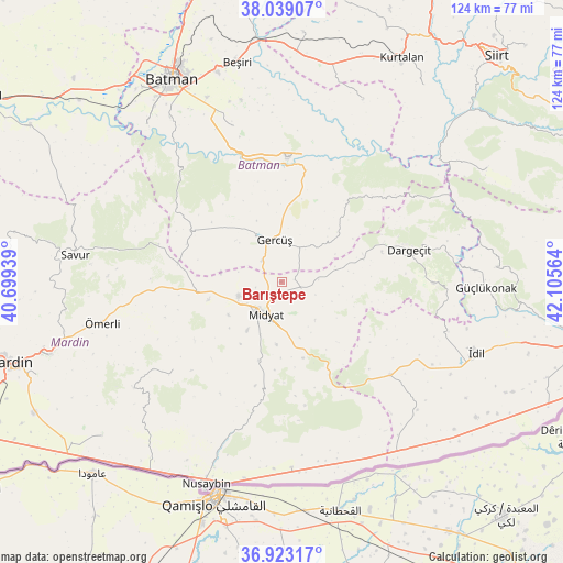
Barıştepe GPS coordinates[2]
37° 28' 59.52" North, 41° 24' 9.036" East
| Map corner | latitude | longitude |
|---|---|---|
| Upper-left | 38.03907°, | 40.69939° |
| Center: | 37.4832°, | 41.40251° |
| Lower-right: | 36.92317°, | 42.10564° |
| Map W x H: | 124.1×124.1 km | = 77.1×77.1mi |
| max Lat: | 42.02683° ⇑75.2% North |
| Barıştepe: | 37.4832° |
| min Lat: | ⇓24.8% South 35.9025° |
| min Long | Barıştepe | max Long |
| 25.90902° | 41.40251° | 44.60099° |
| W 85.3%⇐ | ⇒14.7% E |
Elevation
Elevation of Barıştepe is 968 m = 3176 ft, and this is 250.6 m = 822 ft above average elevation for this country.
| Max E: |
2682 m = 8799 ft | 34.5% |
| Barıştepe | 968 m 3176 ft | |
| Avg. | 717.4 m = 2354 ft | |
Min E: |
0 m = 0 ft | 65.5% |
See also: Turkey elevation on elevation.city.
Geographical zone
Barıştepe is located in North temperate zone (between Tropic of Cancer and the Arctic Circle). Distance of this Northern Tropic circle is 1561.8 km =970.5 mi to South.| Distance of | km | miles | from Barıştepe |
|---|---|---|---|
| North Pole | 5839.3 | 3628.4 | to North |
| Arctic Circle | 3233.4 | 2009.1 | to North |
| Tropic Cancer | 1561.8 | 970.5 | to South |
| Equator | 4167.7 | 2589.7 | to South |


Nearby cities:
15 places around Barıştepe: (largest is in red/bold)
• Acırlı
10 km =6.2 mi,  252°
252°
• Budaklı
12.6 km =7.8 mi,  202°
202°
• Düzoba
15.3 km =9.5 mi,  228°
228°
• Gelinkaya
13.8 km =8.6 mi,  237°
237°
• Gerdzhyush
9.1 km =5.7 mi,  345°
345°
• Gökçepınar
15.7 km =9.8 mi,  41°
41°
• Gülveren
8.1 km =5 mi,  86°
86°
• Kindirip
16.6 km =10.3 mi,  256°
256°
• Midyat
9.1 km =5.7 mi,  218°
218°
• Ortaca
13.6 km =8.5 mi, 94°
• Seri
16.4 km =10.2 mi,  213°
213°
• Yolağzı
6.4 km =4 mi,  317°
317°
• Yolbaşı
13 km =8.1 mi, 215°
• Çavuşlu
13.7 km =8.5 mi,  278°
278°
• Çukuryurt
13.8 km =8.6 mi,  30°
30°
Sources, notices
• [Note1] Compared only with cities in Turkey existing in our database
• [Src1] Map data: © OpenStreetMap contributors (CC-BY-SA)
• [Src2] Other city data from geonames.org with taken over terms of usage.
• [Src3] Geographical zone / Annual Mean Temperature by Robert A. Rohde @ Wikipedia
