Samandağ geodata
Samandağ (Hatay) is a seat of a second-order administrative division; located in Turkey in Europe/Istanbul (GMT+3) time zone. In our database, there are 1323 cities with bigger population. Compared to other cities in Turkey, 99.5% of cities are located further ↑North; 50% of cities are located further ←West and 94.1% of cities have higher elevation than Samandağ. Note1


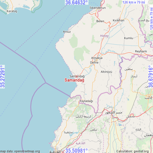
Samandağ GPS coordinates[2]
36° 4' 48.432" North, 35° 58' 33.708" East
| Map corner | latitude | longitude |
|---|---|---|
| Upper-left | 36.64632°, | 35.27291° |
| Center: | 36.08012°, | 35.97603° |
| Lower-right: | 35.50981°, | 36.67916° |
| Map W x H: | 126.4×126.4 km | = 78.5×78.5mi |
| max Lat: | 42.02683° ⇑99.5% North |
| Samandağ: | 36.08012° |
| min Lat: | ⇓0.5% South 35.9025° |
| min Long | Samandağ | max Long |
| 25.90902° | 35.97603° | 44.60099° |
| W 50%⇐ | ⇒50% E |
Elevation
Elevation of Samandağ is 20 m = 66 ft, and this is 697.4 m = 2288 ft below average elevation for this country.
| Max E: |
2682 m = 8799 ft | 94.1% |
| Avg. | 717.4 m = 2354 ft | |
| Samandağ | 20 m = 66 ft | |
Min E: |
0 m = 0 ft | 5.9% |
See also: Turkey elevation on elevation.city.
Geographical zone
Samandağ is located in North temperate zone (between Tropic of Cancer and the Arctic Circle). Distance of this Northern Tropic circle is 1405.8 km =873.5 mi to South.| Distance of | km | miles | from Samandağ |
|---|---|---|---|
| North Pole | 5995.3 | 3725.3 | to North |
| Arctic Circle | 3389.4 | 2106.1 | to North |
| Tropic Cancer | 1405.8 | 873.5 | to South |
| Equator | 4011.7 | 2492.8 | to South |


Nearby cities:
15 places around Samandağ: (largest is in red/bold)
• Aşağıokçular
18.3 km =11.4 mi,  53°
53°
• Balıklıdere
12.4 km =7.7 mi,  68°
68°
• Büyükçat
9.9 km =6.2 mi, 66°
• Gözene
3.4 km =2.1 mi,  119°
119°
• Gümüşgöze
16 km =9.9 mi,  61°
61°
• Güneysöğüt
16 km =9.9 mi, 49°
• Hancağız
12.7 km =7.9 mi, 49°
• Harbiye
15.4 km =9.6 mi, 65°
• Karaçay
11 km =6.8 mi, 55°
• Samankaya
15.7 km =9.8 mi, 60°
• Toygarlı
17.1 km =10.6 mi,  30°
30°
• Uzunbağ
8.6 km =5.3 mi,  38°
38°
• Yeditepe
13 km =8.1 mi,  164°
164°
• Çanakoluk
12 km =7.5 mi, 36°
• Şenköy
15.5 km =9.6 mi,  103°
103°
Sources, notices
• [Note1] Compared only with cities in Turkey existing in our database
• [Src1] Map data: © OpenStreetMap contributors (CC-BY-SA)
• [Src2] Other city data from geonames.org with taken over terms of usage.
• [Src3] Geographical zone / Annual Mean Temperature by Robert A. Rohde @ Wikipedia
