Harbiye geodata
Harbiye (Hatay) is a seat of a third-order administrative division; located in Turkey in Europe/Istanbul (GMT+3) time zone. In our database, there are 1323 cities with bigger population. Compared to other cities in Turkey, 99.3% of cities are located further ↑North; 51.4% of cities are located further ←West and 72% of cities have higher elevation than Harbiye. Note1


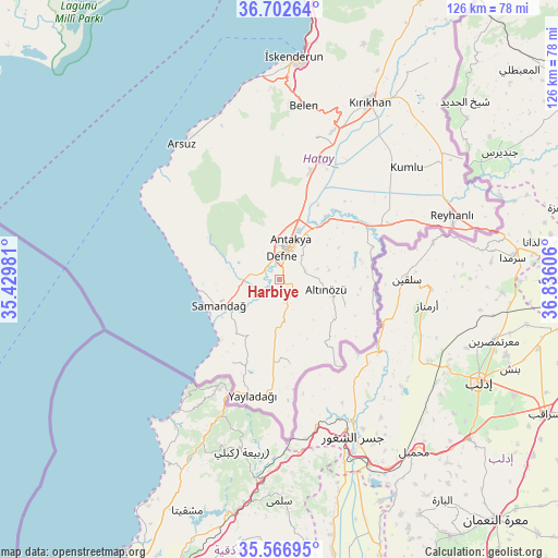
Harbiye GPS coordinates[2]
36° 8' 12.66" North, 36° 7' 58.548" East
| Map corner | latitude | longitude |
|---|---|---|
| Upper-left | 36.70264°, | 35.42981° |
| Center: | 36.13685°, | 36.13293° |
| Lower-right: | 35.56695°, | 36.83606° |
| Map W x H: | 126.3×126.3 km | = 78.5×78.5mi |
| max Lat: | 42.02683° ⇑99.3% North |
| Harbiye: | 36.13685° |
| min Lat: | ⇓0.7% South 35.9025° |
| min Long | Harbiye | max Long |
| 25.90902° | 36.13293° | 44.60099° |
| W 51.4%⇐ | ⇒48.6% E |
Elevation
Elevation of Harbiye is 237 m = 778 ft, and this is 480.4 m = 1576 ft below average elevation for this country.
| Max E: |
2682 m = 8799 ft | 72% |
| Avg. | 717.4 m = 2354 ft | |
| Harbiye | 237 m = 778 ft | |
Min E: |
0 m = 0 ft | 28% |
See also: Turkey elevation on elevation.city.
Geographical zone
Harbiye is located in North temperate zone (between Tropic of Cancer and the Arctic Circle). Distance of this Northern Tropic circle is 1412.1 km =877.4 mi to South.| Distance of | km | miles | from Harbiye |
|---|---|---|---|
| North Pole | 5989 | 3721.4 | to North |
| Arctic Circle | 3383.1 | 2102.2 | to North |
| Tropic Cancer | 1412.1 | 877.4 | to South |
| Equator | 4018 | 2496.7 | to South |


Nearby cities:
15 places around Harbiye: (largest is in red/bold)
• Antakya
8.1 km =5 mi,  15°
15°
• Aşağıokçular
4.6 km =2.9 mi,  8°
8°
• Balıklıdere
3.1 km =1.9 mi,  235°
235°
• Büyükçat
5.5 km =3.4 mi, 244°
• Dursunlu
4.1 km =2.5 mi,  33°
33°
• Gümüşgöze
1.2 km =0.7 mi,  359°
359°
• Güneysöğüt
4.5 km =2.8 mi,  335°
335°
• Hancağız
4.9 km =3 mi,  293°
293°
• Hıdırbey
7.9 km =4.9 mi, 356°
• Karaçay
5 km =3.1 mi,  268°
268°
• Samankaya
1.5 km =0.9 mi, 344°
• Tepehan
8.9 km =5.5 mi,  74°
74°
• Uzunbağ
8.7 km =5.4 mi, 272°
• Çanakoluk
7.7 km =4.8 mi,  295°
295°
• Şenköy
9.9 km =6.2 mi,  174°
174°
Sources, notices
• [Note1] Compared only with cities in Turkey existing in our database
• [Src1] Map data: © OpenStreetMap contributors (CC-BY-SA)
• [Src2] Other city data from geonames.org with taken over terms of usage.
• [Src3] Geographical zone / Annual Mean Temperature by Robert A. Rohde @ Wikipedia
