Özbek geodata
Özbek (Mardin) is a populated place; located in Turkey in Europe/Istanbul (GMT+3) time zone. With population of 1,002 people, there are 1089 cities with bigger population in this country. Compared to other cities in Turkey, 84.2% of cities are located further ↑North; 87.7% of cities are located further ←West and 54.4% of cities have higher elevation than Özbek. Note1


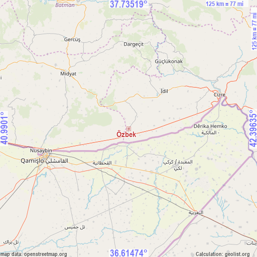
Özbek GPS coordinates[2]
37° 10' 37.344" North, 41° 41' 35.592" East
| Map corner | latitude | longitude |
|---|---|---|
| Upper-left | 37.73519°, | 40.9901° |
| Center: | 37.17704°, | 41.69322° |
| Lower-right: | 36.61474°, | 42.39635° |
| Map W x H: | 124.6×124.6 km | = 77.4×77.4mi |
| max Lat: | 42.02683° ⇑84.2% North |
| Özbek: | 37.17704° |
| min Lat: | ⇓15.8% South 35.9025° |
| min Long | Özbek | max Long |
| 25.90902° | 41.69322° | 44.60099° |
| W 87.7%⇐ | ⇒12.3% E |
Elevation
Elevation of Özbek is 606 m = 1988 ft, and this is 111.4 m = 365 ft below average elevation for this country.
| Max E: |
2682 m = 8799 ft | 54.4% |
| Avg. | 717.4 m = 2354 ft | |
| Özbek | 606 m = 1988 ft | |
Min E: |
0 m = 0 ft | 45.6% |
See also: Turkey elevation on elevation.city.
Geographical zone
Özbek is located in North temperate zone (between Tropic of Cancer and the Arctic Circle). Distance of this Northern Tropic circle is 1527.8 km =949.3 mi to South.| Distance of | km | miles | from Özbek |
|---|---|---|---|
| North Pole | 5873.4 | 3649.6 | to North |
| Arctic Circle | 3267.5 | 2030.3 | to North |
| Tropic Cancer | 1527.8 | 949.3 | to South |
| Equator | 4133.7 | 2568.6 | to South |


Nearby cities:
15 places around Özbek: (largest is in red/bold)
• Aksoy
5.8 km =3.6 mi,  341°
341°
• Alakamış
8.7 km =5.4 mi,  103°
103°
• Haberli
15.7 km =9.8 mi,  334°
334°
• Hasantepe
18.7 km =11.6 mi,  252°
252°
• Karalar
13.8 km =8.6 mi,  353°
353°
• Köyceğiz
16.4 km =10.2 mi,  89°
89°
• Oyalı
6.4 km =4 mi,  39°
39°
• Oymak
17.1 km =10.6 mi,  60°
60°
• Pınarbaşı
17.6 km =10.9 mi,  76°
76°
• Serkan
4.7 km =2.9 mi,  115°
115°
• Tepeköy
17.9 km =11.1 mi, 40°
• Ulak
14.2 km =8.8 mi, 41°
• Uğrak
6.7 km =4.2 mi,  70°
70°
• Varımlı
12.5 km =7.8 mi, 83°
• Yazman
9.9 km =6.2 mi, 37°
Sources, notices
• [Note1] Compared only with cities in Turkey existing in our database
• [Src1] Map data: © OpenStreetMap contributors (CC-BY-SA)
• [Src2] Other city data from geonames.org with taken over terms of usage.
• [Src3] Geographical zone / Annual Mean Temperature by Robert A. Rohde @ Wikipedia
