Haberli geodata
Haberli (Mardin) is a seat of a third-order administrative division; located in Turkey in Europe/Istanbul (GMT+3) time zone. With population of 174 people, there are 1322 cities with bigger population in this country. Compared to other cities in Turkey, 80.3% of cities are located further ↑North; 87% of cities are located further ←West and 65.2% of cities have lower elevation than Haberli. Note1


Haberli GPS coordinates[2]
37° 18' 18.36" North, 41° 37' 3.288" East
| Map corner | latitude | longitude |
|---|---|---|
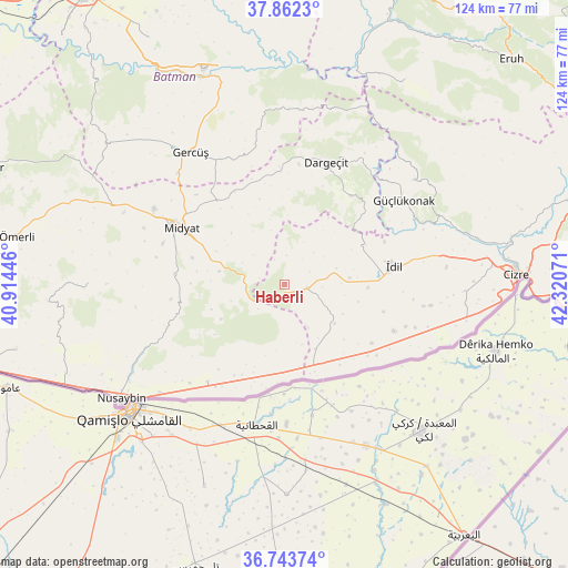
| Upper-left | 37.8623°, | 40.91446° |
| Center: | 37.3051°, | 41.61758° |
| Lower-right: | 36.74374°, | 42.32071° |
| Map W x H: | 124.4×124.4 km | = 77.3×77.3mi |
| max Lat: | 42.02683° ⇑80.3% North |
| Haberli: | 37.3051° |
| min Lat: | ⇓19.7% South 35.9025° |
| min Long | Haberli | max Long |
| 25.90902° | 41.61758° | 44.60099° |
| W 87%⇐ | ⇒13% E |
Elevation
Elevation of Haberli is 963 m = 3159 ft, and this is 245.6 m = 806 ft above average elevation for this country.
| Max E: |
2682 m = 8799 ft | 34.8% |
| Haberli | 963 m 3159 ft | |
| Avg. | 717.4 m = 2354 ft | |
Min E: |
0 m = 0 ft | 65.2% |
See also: Turkey elevation on elevation.city.
Geographical zone
Haberli is located in North temperate zone (between Tropic of Cancer and the Arctic Circle). Distance of this Northern Tropic circle is 1542 km =958.2 mi to South.| Distance of | km | miles | from Haberli |
|---|---|---|---|
| North Pole | 5859.1 | 3640.7 | to North |
| Arctic Circle | 3253.2 | 2021.4 | to North |
| Tropic Cancer | 1542 | 958.2 | to South |
| Equator | 4147.9 | 2577.4 | to South |


Nearby cities:
15 places around Haberli: (largest is in red/bold)
• Aksoy
10 km =6.2 mi,  151°
151°
• Alakamış
22.2 km =13.8 mi,  136°
136°
• Başyurt
13.9 km =8.6 mi,  9°
9°
• Dumanlı
9.5 km =5.9 mi,  42°
42°
• Karalar
5.2 km =3.2 mi,  95°
95°
• Ortaca
19.5 km =12.1 mi,  343°
343°
• Oyalı
14.2 km =8.8 mi,  131°
131°
• Oymak
22.4 km =13.9 mi,  105°
105°
• Serkan
19.6 km =12.2 mi, 146°
• Tepeköy
18.3 km =11.4 mi,  91°
91°
• Ulak
16.6 km =10.3 mi, 102°
• Uğrak
17.7 km =11 mi, 132°
• Yayvantepe
8.6 km =5.3 mi,  267°
267°
• Yazman
14.3 km =8.9 mi,  116°
116°
• Özbek
15.7 km =9.8 mi, 154°
Sources, notices
• [Note1] Compared only with cities in Turkey existing in our database
• [Src1] Map data: © OpenStreetMap contributors (CC-BY-SA)
• [Src2] Other city data from geonames.org with taken over terms of usage.
• [Src3] Geographical zone / Annual Mean Temperature by Robert A. Rohde @ Wikipedia
