Karkamış geodata
Karkamış (Gaziantep) is a seat of a second-order administrative division; located in Turkey in Europe/Istanbul (GMT+3) time zone. With population of 4,951 people, there are 728 cities with bigger population in this country. Compared to other cities in Turkey, 92.6% of cities are located further ↑North; 61.7% of cities are located further ←West and 68.1% of cities have higher elevation than Karkamış. Note1


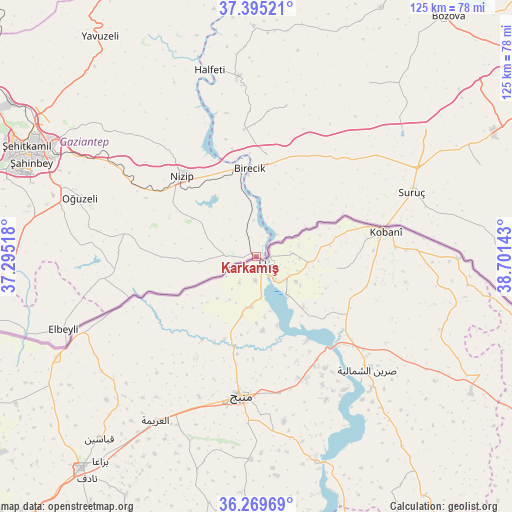
Karkamış GPS coordinates[2]
36° 50' 4.272" North, 37° 59' 53.88" East
| Map corner | latitude | longitude |
|---|---|---|
| Upper-left | 37.39521°, | 37.29518° |
| Center: | 36.83452°, | 37.9983° |
| Lower-right: | 36.26969°, | 38.70143° |
| Map W x H: | 125.1×125.1 km | = 77.7×77.7mi |
| max Lat: | 42.02683° ⇑92.6% North |
| Karkamış: | 36.83452° |
| min Lat: | ⇓7.4% South 35.9025° |
| min Long | Karkamış | max Long |
| 25.90902° | 37.9983° | 44.60099° |
| W 61.7%⇐ | ⇒38.3% E |
Elevation
Elevation of Karkamış is 357 m = 1171 ft, and this is 360.4 m = 1182 ft below average elevation for this country.
| Max E: |
2682 m = 8799 ft | 68.1% |
| Avg. | 717.4 m = 2354 ft | |
| Karkamış | 357 m = 1171 ft | |
Min E: |
0 m = 0 ft | 31.9% |
See also: Turkey elevation on elevation.city.
Geographical zone
Karkamış is located in North temperate zone (between Tropic of Cancer and the Arctic Circle). Distance of this Northern Tropic circle is 1489.7 km =925.7 mi to South.| Distance of | km | miles | from Karkamış |
|---|---|---|---|
| North Pole | 5911.4 | 3673.2 | to North |
| Arctic Circle | 3305.6 | 2054 | to North |
| Tropic Cancer | 1489.7 | 925.7 | to South |
| Equator | 4095.6 | 2544.9 | to South |


Nearby cities:
15 places around Karkamış: (largest is in red/bold)
• Akarçay
9.8 km =6.1 mi,  15°
15°
• Arslanlı
19.3 km =12 mi,  28°
28°
• Birecik
21.3 km =13.2 mi,  355°
355°
• Elifoğlu
12.5 km =7.8 mi, 356°
• Gevence
16.2 km =10.1 mi,  302°
302°
• Kelekli
9 km =5.6 mi, 355°
• Kirap
26.7 km =16.6 mi,  280°
280°
• Küçükkendirci
31.9 km =19.8 mi,  75°
75°
• Mağaralı
16.4 km =10.2 mi, 24°
• Mürşitpınar
32 km =19.9 mi, 76°
• Nizip
26.6 km =16.5 mi,  317°
317°
• Uluyatır
30.6 km =19 mi, 297°
• Yeserti
13.7 km =8.5 mi, 278°
• Çiflikköy
18 km =11.2 mi,  267°
267°
• İkizce
20.2 km =12.6 mi, 278°
Sources, notices
• [Note1] Compared only with cities in Turkey existing in our database
• [Src1] Map data: © OpenStreetMap contributors (CC-BY-SA)
• [Src2] Other city data from geonames.org with taken over terms of usage.
• [Src3] Geographical zone / Annual Mean Temperature by Robert A. Rohde @ Wikipedia
