Birecik geodata
Birecik (Şanlıurfa) is a seat of a second-order administrative division; located in Turkey in Europe/Istanbul (GMT+3) time zone. With population of 44,284 people, there are 194 cities with bigger population in this country. Compared to other cities in Turkey, 87.3% of cities are located further ↑North; 61.5% of cities are located further ←West and 68.6% of cities have higher elevation than Birecik. Note1


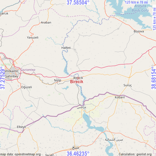
Birecik GPS coordinates[2]
37° 1' 32.772" North, 37° 58' 42.276" East
| Map corner | latitude | longitude |
|---|---|---|
| Upper-left | 37.58504°, | 37.27529° |
| Center: | 37.02577°, | 37.97841° |
| Lower-right: | 36.46235°, | 38.68154° |
| Map W x H: | 124.8×124.8 km | = 77.5×77.5mi |
| max Lat: | 42.02683° ⇑87.3% North |
| Birecik: | 37.02577° |
| min Lat: | ⇓12.7% South 35.9025° |
| min Long | Birecik | max Long |
| 25.90902° | 37.97841° | 44.60099° |
| W 61.5%⇐ | ⇒38.5% E |
Elevation
Elevation of Birecik is 351 m = 1152 ft, and this is 366.4 m = 1202 ft below average elevation for this country.
| Max E: |
2682 m = 8799 ft | 68.6% |
| Avg. | 717.4 m = 2354 ft | |
| Birecik | 351 m = 1152 ft | |
Min E: |
0 m = 0 ft | 31.4% |
See also: Birecik elevation on elevation.city.
Geographical zone
Birecik is located in North temperate zone (between Tropic of Cancer and the Arctic Circle). Distance of this Northern Tropic circle is 1511 km =938.9 mi to South.| Distance of | km | miles | from Birecik |
|---|---|---|---|
| North Pole | 5890.2 | 3660 | to North |
| Arctic Circle | 3284.3 | 2040.8 | to North |
| Tropic Cancer | 1511 | 938.9 | to South |
| Equator | 4116.9 | 2558.1 | to South |


Nearby cities:
15 places around Birecik: (largest is in red/bold)
• Akarçay
12.6 km =7.8 mi,  160°
160°
• Arslanlı
11.7 km =7.3 mi,  111°
111°
• Böğürtlen
18.1 km =11.2 mi,  30°
30°
• Elifoğlu
8.9 km =5.5 mi,  173°
173°
• Gevence
17.3 km =10.7 mi,  223°
223°
• Halfeti
26.3 km =16.3 mi,  338°
338°
• Karkamış
21.3 km =13.2 mi,  175°
175°
• Kelekli
12.4 km =7.7 mi, 174°
• Mağaralı
10.6 km =6.6 mi,  126°
126°
• Nizip
16.5 km =10.3 mi,  263°
263°
• Sekili
27.7 km =17.2 mi, 259°
• Uluyatır
26.2 km =16.3 mi,  254°
254°
• Yeserti
22.6 km =14 mi,  211°
211°
• Çiflikköy
27.4 km =17 mi, 216°
• İkizce
25.7 km =16 mi, 224°
Sources, notices
• [Note1] Compared only with cities in Turkey existing in our database
• [Src1] Map data: © OpenStreetMap contributors (CC-BY-SA)
• [Src2] Other city data from geonames.org with taken over terms of usage.
• [Src3] Geographical zone / Annual Mean Temperature by Robert A. Rohde @ Wikipedia
