Ashagy-Tomik geodata
Ashagy-Tomik (Mardin) is a populated place; located in Turkey in Europe/Istanbul (GMT+3) time zone. With population of 638 people, there are 1230 cities with bigger population in this country. Compared to other cities in Turkey, 81.9% of cities are located further ↑North; 78.1% of cities are located further ←West and 57.6% of cities have higher elevation than Ashagy-Tomik. Note1


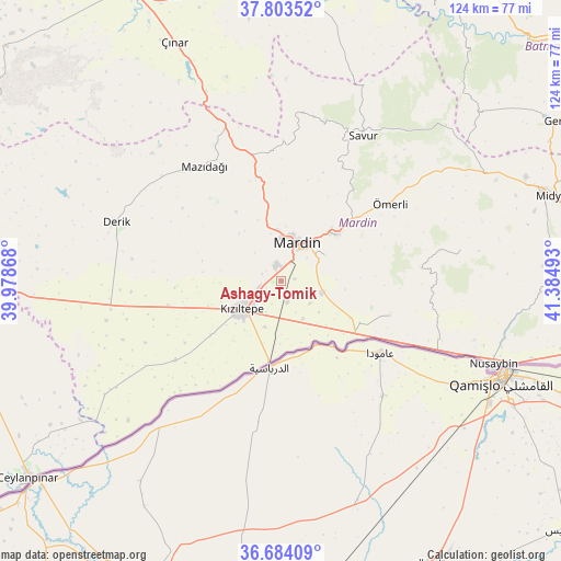
Ashagy-Tomik GPS coordinates[2]
37° 14' 45.168" North, 40° 40' 54.48" East
| Map corner | latitude | longitude |
|---|---|---|
| Upper-left | 37.80352°, | 39.97868° |
| Center: | 37.24588°, | 40.6818° |
| Lower-right: | 36.68409°, | 41.38493° |
| Map W x H: | 124.5×124.5 km | = 77.4×77.4mi |
| max Lat: | 42.02683° ⇑81.9% North |
| Ashagy-Tomik: | 37.24588° |
| min Lat: | ⇓18.1% South 35.9025° |
| min Long | Ashagy-Tomik | max Long |
| 25.90902° | 40.6818° | 44.60099° |
| W 78.1%⇐ | ⇒21.9% E |
Elevation
Elevation of Ashagy-Tomik is 546 m = 1791 ft, and this is 171.4 m = 562 ft below average elevation for this country.
| Max E: |
2682 m = 8799 ft | 57.6% |
| Avg. | 717.4 m = 2354 ft | |
| Ashagy-Tomik | 546 m = 1791 ft | |
Min E: |
0 m = 0 ft | 42.4% |
See also: Turkey elevation on elevation.city.
Geographical zone
Ashagy-Tomik is located in North temperate zone (between Tropic of Cancer and the Arctic Circle). Distance of this Northern Tropic circle is 1535.4 km =954.1 mi to South.| Distance of | km | miles | from Ashagy-Tomik |
|---|---|---|---|
| North Pole | 5865.7 | 3644.8 | to North |
| Arctic Circle | 3259.8 | 2025.5 | to North |
| Tropic Cancer | 1535.4 | 954.1 | to South |
| Equator | 4141.4 | 2573.3 | to South |


Nearby cities:
15 places around Ashagy-Tomik: (largest is in red/bold)
• Boztepe
7.6 km =4.7 mi,  154°
154°
• Elbeyli
7.7 km =4.8 mi,  205°
205°
• Eryeri
7.8 km =4.8 mi,  45°
45°
• Eskin
3.4 km =2.1 mi,  185°
185°
• Eymirli
8.4 km =5.2 mi,  176°
176°
• Eşme
10.6 km =6.6 mi,  199°
199°
• Göllü
3 km =1.9 mi,  78°
78°
• Kocalar
4.2 km =2.6 mi,  301°
301°
• Kumlu
9.5 km =5.9 mi, 149°
• Mardin
9.3 km =5.8 mi,  36°
36°
• Ortaköy
9.5 km =5.9 mi,  106°
106°
• Sancarlı
4.5 km =2.8 mi,  291°
291°
• Selah
4.7 km =2.9 mi,  162°
162°
• Yaylı
8 km =5 mi,  126°
126°
• Yukarı Azıklı
2.3 km =1.4 mi,  348°
348°
Sources, notices
• [Note1] Compared only with cities in Turkey existing in our database
• [Src1] Map data: © OpenStreetMap contributors (CC-BY-SA)
• [Src2] Other city data from geonames.org with taken over terms of usage.
• [Src3] Geographical zone / Annual Mean Temperature by Robert A. Rohde @ Wikipedia
