Boztepe geodata
Boztepe (Mardin) is a populated place; located in Turkey in Europe/Istanbul (GMT+3) time zone. With population of 505 people, there are 1313 cities with bigger population in this country. Compared to other cities in Turkey, 83.8% of cities are located further ↑North; 78.6% of cities are located further ←West and 58.9% of cities have higher elevation than Boztepe. Note1


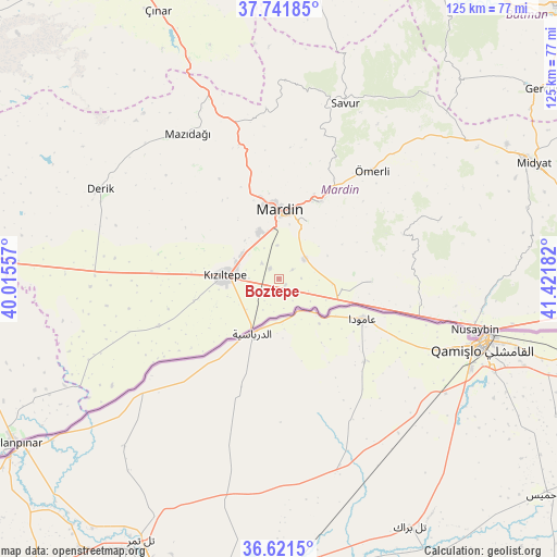
Boztepe GPS coordinates[2]
37° 11' 1.5" North, 40° 43' 7.284" East
| Map corner | latitude | longitude |
|---|---|---|
| Upper-left | 37.74185°, | 40.01557° |
| Center: | 37.18375°, | 40.71869° |
| Lower-right: | 36.6215°, | 41.42182° |
| Map W x H: | 124.6×124.6 km | = 77.4×77.4mi |
| max Lat: | 42.02683° ⇑83.8% North |
| Boztepe: | 37.18375° |
| min Lat: | ⇓16.2% South 35.9025° |
| min Long | Boztepe | max Long |
| 25.90902° | 40.71869° | 44.60099° |
| W 78.6%⇐ | ⇒21.4% E |
Elevation
Elevation of Boztepe is 524 m = 1719 ft, and this is 193.4 m = 635 ft below average elevation for this country.
| Max E: |
2682 m = 8799 ft | 58.9% |
| Avg. | 717.4 m = 2354 ft | |
| Boztepe | 524 m = 1719 ft | |
Min E: |
0 m = 0 ft | 41.1% |
See also: Turkey elevation on elevation.city.
Geographical zone
Boztepe is located in North temperate zone (between Tropic of Cancer and the Arctic Circle). Distance of this Northern Tropic circle is 1528.5 km =949.8 mi to South.| Distance of | km | miles | from Boztepe |
|---|---|---|---|
| North Pole | 5872.6 | 3649.1 | to North |
| Arctic Circle | 3266.7 | 2029.8 | to North |
| Tropic Cancer | 1528.5 | 949.8 | to South |
| Equator | 4134.4 | 2569 | to South |


Nearby cities:
15 places around Boztepe: (largest is in red/bold)
• Arpatepe
8.6 km =5.3 mi,  125°
125°
• Ashagy-Tomik
7.6 km =4.7 mi,  334°
334°
• Doyuran
9.9 km =6.2 mi,  226°
226°
• Elbeyli
6.6 km =4.1 mi,  269°
269°
• Eskin
5 km =3.1 mi,  314°
314°
• Eymirli
3.2 km =2 mi,  242°
242°
• Eşme
7.5 km =4.7 mi,  245°
245°
• Göllü
7.5 km =4.7 mi,  357°
357°
• Hatunlu
5.8 km =3.6 mi,  147°
147°
• Kumlu
2 km =1.2 mi, 130°
• Kuyulu
7.1 km =4.4 mi,  113°
113°
• Ortaköy
7.2 km =4.5 mi,  54°
54°
• Selah
3.1 km =1.9 mi,  322°
322°
• Shaklan
5.3 km =3.3 mi,  118°
118°
• Yaylı
3.8 km =2.4 mi,  55°
55°
Sources, notices
• [Note1] Compared only with cities in Turkey existing in our database
• [Src1] Map data: © OpenStreetMap contributors (CC-BY-SA)
• [Src2] Other city data from geonames.org with taken over terms of usage.
• [Src3] Geographical zone / Annual Mean Temperature by Robert A. Rohde @ Wikipedia
