Batikent geodata
Batikent (Ankara) is a section of populated place; located in Turkey in Europe/Istanbul (GMT+3) time zone. With population of 300,000 people, there are 32 cities with bigger population in this country. Compared to other cities in Turkey, 68.6% of cities are located further ↓South; 63.2% of cities are located further →East and 58.9% of cities have lower elevation than Batikent. Note1


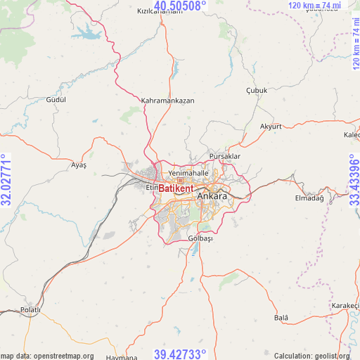
Batikent GPS coordinates[2]
39° 58' 5.988" North, 32° 43' 50.988" East
| Map corner | latitude | longitude |
|---|---|---|
| Upper-left | 40.50508°, | 32.02771° |
| Center: | 39.96833°, | 32.73083° |
| Lower-right: | 39.42733°, | 33.43396° |
| Map W x H: | 119.8×119.8 km | = 74.4×74.4mi |
| max Lat: | 42.02683° ⇑31.4% North |
| Batikent: | 39.96833° |
| min Lat: | ⇓68.6% South 35.9025° |
| min Long | Batikent | max Long |
| 25.90902° | 32.73083° | 44.60099° |
| W 36.8%⇐ | ⇒63.2% E |
Elevation
Elevation of Batikent is 862 m = 2828 ft, and this is 144.6 m = 474 ft above average elevation for this country.
| Max E: |
2682 m = 8799 ft | 41.1% |
| Batikent | 862 m 2828 ft | |
| Avg. | 717.4 m = 2354 ft | |
Min E: |
0 m = 0 ft | 58.9% |
See also: Batikent elevation on elevation.city.
Geographical zone
Batikent is located in North temperate zone (between Tropic of Cancer and the Arctic Circle). Distance of this Northern Tropic circle is 1838.1 km =1142.1 mi to South.| Distance of | km | miles | from Batikent |
|---|---|---|---|
| North Pole | 5563 | 3456.7 | to North |
| Arctic Circle | 2957.1 | 1837.5 | to North |
| Tropic Cancer | 1838.1 | 1142.1 | to South |
| Equator | 4444.1 | 2761.4 | to South |


Nearby cities:
15 places around Batikent: (largest is in red/bold)
• Akyurt
35.5 km =22.1 mi,  58°
58°
• Ankara
11.8 km =7.3 mi,  117°
117°
• Ayaş
34.4 km =21.4 mi,  279°
279°
• Elmadağ
42.9 km =26.7 mi,  97°
97°
• Etimesgut
8.5 km =5.3 mi,  258°
258°
• Gölbaşı
20.9 km =13 mi,  161°
161°
• Kazan
29.6 km =18.4 mi,  352°
352°
• Mamak
15.6 km =9.7 mi, 101°
• Pazar
40.3 km =25 mi,  2°
2°
• Pursaklar
15.7 km =9.8 mi, 63°
• Temelli
41.8 km =26 mi,  230°
230°
• Çankaya
12.6 km =7.8 mi, 116°
• Çeltikçi
45.7 km =28.4 mi,  329°
329°
• Çubuk
39.5 km =24.5 mi,  40°
40°
• İkizce
41.9 km =26 mi,  188°
188°
Sources, notices
• [Note1] Compared only with cities in Turkey existing in our database
• [Src1] Map data: © OpenStreetMap contributors (CC-BY-SA)
• [Src2] Other city data from geonames.org with taken over terms of usage.
• [Src3] Geographical zone / Annual Mean Temperature by Robert A. Rohde @ Wikipedia
