Etimesgut geodata
Etimesgut (Ankara) is a seat of a second-order administrative division; located in Turkey in Europe/Istanbul (GMT+3) time zone. In our database, there are 1323 cities with bigger population. Compared to other cities in Turkey, 68.4% of cities are located further ↓South; 63.8% of cities are located further →East and 55.8% of cities have lower elevation than Etimesgut. Note1


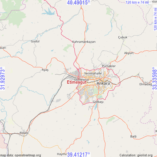
Etimesgut GPS coordinates[2]
39° 57' 11.808" North, 32° 37' 58.26" East
| Map corner | latitude | longitude |
|---|---|---|
| Upper-left | 40.49015°, | 31.92973° |
| Center: | 39.95328°, | 32.63285° |
| Lower-right: | 39.41217°, | 33.33598° |
| Map W x H: | 119.9×119.9 km | = 74.5×74.5mi |
| max Lat: | 42.02683° ⇑31.6% North |
| Etimesgut: | 39.95328° |
| min Lat: | ⇓68.4% South 35.9025° |
| min Long | Etimesgut | max Long |
| 25.90902° | 32.63285° | 44.60099° |
| W 36.2%⇐ | ⇒63.8% E |
Elevation
Elevation of Etimesgut is 805 m = 2641 ft, and this is 87.6 m = 287 ft above average elevation for this country.
| Max E: |
2682 m = 8799 ft | 44.2% |
| Etimesgut | 805 m 2641 ft | |
| Avg. | 717.4 m = 2354 ft | |
Min E: |
0 m = 0 ft | 55.8% |
See also: Turkey elevation on elevation.city.
Geographical zone
Etimesgut is located in North temperate zone (between Tropic of Cancer and the Arctic Circle). Distance of this Northern Tropic circle is 1836.5 km =1141.1 mi to South.| Distance of | km | miles | from Etimesgut |
|---|---|---|---|
| North Pole | 5564.7 | 3457.7 | to North |
| Arctic Circle | 2958.8 | 1838.5 | to North |
| Tropic Cancer | 1836.5 | 1141.1 | to South |
| Equator | 4442.4 | 2760.4 | to South |


Nearby cities:
15 places around Etimesgut: (largest is in red/bold)
• Akyurt
43.6 km =27.1 mi,  62°
62°
• Ankara
19.2 km =11.9 mi,  101°
101°
• Ayaş
26.6 km =16.5 mi,  285°
285°
• Batikent
8.5 km =5.3 mi,  78°
78°
• Gölbaşı
23.5 km =14.6 mi,  140°
140°
• Güdül
43.6 km =27.1 mi,  310°
310°
• Kazan
31.3 km =19.4 mi,  7°
7°
• Mamak
23.7 km =14.7 mi,  93°
93°
• Pazar
43 km =26.7 mi, 13°
• Pursaklar
24 km =14.9 mi,  68°
68°
• Temelli
34.5 km =21.4 mi,  223°
223°
• Çankaya
20 km =12.4 mi, 101°
• Çeltikçi
43.7 km =27.2 mi,  339°
339°
• Çubuk
46.5 km =28.9 mi,  46°
46°
• İkizce
39.9 km =24.8 mi,  176°
176°
Sources, notices
• [Note1] Compared only with cities in Turkey existing in our database
• [Src1] Map data: © OpenStreetMap contributors (CC-BY-SA)
• [Src2] Other city data from geonames.org with taken over terms of usage.
• [Src3] Geographical zone / Annual Mean Temperature by Robert A. Rohde @ Wikipedia
