Ayaş geodata
Ayaş (Ankara) is a populated place; located in Turkey in Europe/Istanbul (GMT+3) time zone. With population of 8,570 people, there are 553 cities with bigger population in this country. Compared to other cities in Turkey, 69.3% of cities are located further ↓South; 65.2% of cities are located further →East and 64.6% of cities have lower elevation than Ayaş. Note1


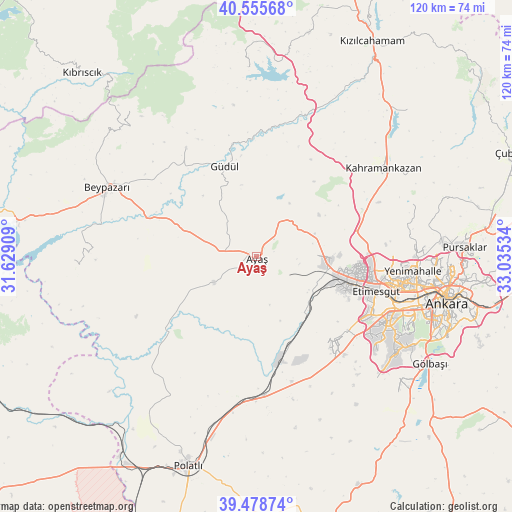
Ayaş GPS coordinates[2]
40° 1' 9.588" North, 32° 19' 55.956" East
| Map corner | latitude | longitude |
|---|---|---|
| Upper-left | 40.55568°, | 31.62909° |
| Center: | 40.01933°, | 32.33221° |
| Lower-right: | 39.47874°, | 33.03534° |
| Map W x H: | 119.7×119.7 km | = 74.4×74.4mi |
| max Lat: | 42.02683° ⇑30.7% North |
| Ayaş: | 40.01933° |
| min Lat: | ⇓69.3% South 35.9025° |
| min Long | Ayaş | max Long |
| 25.90902° | 32.33221° | 44.60099° |
| W 34.8%⇐ | ⇒65.2% E |
Elevation
Elevation of Ayaş is 953 m = 3127 ft, and this is 235.6 m = 773 ft above average elevation for this country.
| Max E: |
2682 m = 8799 ft | 35.4% |
| Ayaş | 953 m 3127 ft | |
| Avg. | 717.4 m = 2354 ft | |
Min E: |
0 m = 0 ft | 64.6% |
See also: Turkey elevation on elevation.city.
Geographical zone
Ayaş is located in North temperate zone (between Tropic of Cancer and the Arctic Circle). Distance of this Northern Tropic circle is 1843.8 km =1145.7 mi to South.| Distance of | km | miles | from Ayaş |
|---|---|---|---|
| North Pole | 5557.3 | 3453.1 | to North |
| Arctic Circle | 2951.4 | 1833.9 | to North |
| Tropic Cancer | 1843.8 | 1145.7 | to South |
| Equator | 4449.7 | 2764.9 | to South |


Nearby cities:
15 places around Ayaş: (largest is in red/bold)
• Ankara
45.8 km =28.5 mi,  103°
103°
• Batikent
34.4 km =21.4 mi, 99°
• Beypazarı
38.7 km =24 mi,  295°
295°
• Etimesgut
26.6 km =16.5 mi,  105°
105°
• Gelegra
42.6 km =26.5 mi,  269°
269°
• Gölbaşı
48 km =29.8 mi,  122°
122°
• Güdül
22.5 km =14 mi,  340°
340°
• Karaşar
45 km =28 mi,  319°
319°
• Kazan
38.1 km =23.7 mi,  51°
51°
• Peçenek
44.4 km =27.6 mi,  357°
357°
• Pursaklar
48 km =29.8 mi,  88°
88°
• Temelli
32.5 km =20.2 mi,  176°
176°
• Uruş
30.4 km =18.9 mi,  327°
327°
• Çankaya
46.6 km =29 mi, 104°
• Çeltikçi
35.2 km =21.9 mi,  17°
17°
Sources, notices
• [Note1] Compared only with cities in Turkey existing in our database
• [Src1] Map data: © OpenStreetMap contributors (CC-BY-SA)
• [Src2] Other city data from geonames.org with taken over terms of usage.
• [Src3] Geographical zone / Annual Mean Temperature by Robert A. Rohde @ Wikipedia
