Yağlıdere geodata
Yağlıdere (Giresun) is a seat of a second-order administrative division; located in Turkey in Europe/Istanbul (GMT+3) time zone. In our database, there are 1323 cities with bigger population. Compared to other cities in Turkey, 85% of cities are located further ↓South; 64.8% of cities are located further ←West and 67.9% of cities have higher elevation than Yağlıdere. Note1


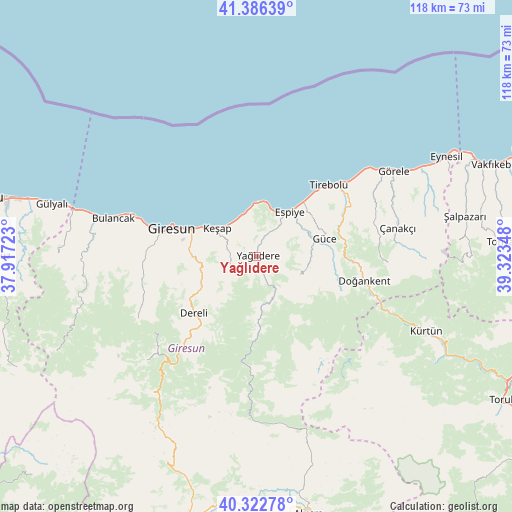
Yağlıdere GPS coordinates[2]
40° 51' 24.192" North, 38° 37' 13.26" East
| Map corner | latitude | longitude |
|---|---|---|
| Upper-left | 41.38639°, | 37.91723° |
| Center: | 40.85672°, | 38.62035° |
| Lower-right: | 40.32278°, | 39.32348° |
| Map W x H: | 118.3×118.3 km | = 73.5×73.5mi |
| max Lat: | 42.02683° ⇑15% North |
| Yağlıdere: | 40.85672° |
| min Lat: | ⇓85% South 35.9025° |
| min Long | Yağlıdere | max Long |
| 25.90902° | 38.62035° | 44.60099° |
| W 64.8%⇐ | ⇒35.2% E |
Elevation
Elevation of Yağlıdere is 361 m = 1184 ft, and this is 356.4 m = 1169 ft below average elevation for this country.
| Max E: |
2682 m = 8799 ft | 67.9% |
| Avg. | 717.4 m = 2354 ft | |
| Yağlıdere | 361 m = 1184 ft | |
Min E: |
0 m = 0 ft | 32.1% |
See also: Turkey elevation on elevation.city.
Geographical zone
Yağlıdere is located in North temperate zone (between Tropic of Cancer and the Arctic Circle). Distance of this Northern Tropic circle is 1936.9 km =1203.5 mi to South.| Distance of | km | miles | from Yağlıdere |
|---|---|---|---|
| North Pole | 5464.2 | 3395.3 | to North |
| Arctic Circle | 2858.3 | 1776.1 | to North |
| Tropic Cancer | 1936.9 | 1203.5 | to South |
| Equator | 4542.8 | 2822.8 | to South |


Nearby cities:
15 places around Yağlıdere: (largest is in red/bold)
• Bulancak
33.9 km =21.1 mi,  285°
285°
• Dereli
19.8 km =12.3 mi,  228°
228°
• Doğankent
25.6 km =15.9 mi,  102°
102°
• Espiye
12.2 km =7.6 mi,  34°
34°
• Eymür
21.2 km =13.2 mi,  92°
92°
• Giresun
20.7 km =12.9 mi, 288°
• Görele
37.5 km =23.3 mi,  58°
58°
• Güce
15.5 km =9.6 mi,  74°
74°
• Karabulduk
7.2 km =4.5 mi,  235°
235°
• Keşap
11.6 km =7.2 mi,  300°
300°
• Kürtün
43.8 km =27.2 mi,  114°
114°
• Piraziz
42.3 km =26.3 mi,  279°
279°
• Tirebolu
23.3 km =14.5 mi,  44°
44°
• Yavuzkemal
30 km =18.6 mi, 232°
• Çanakçı
31.5 km =19.6 mi,  78°
78°
Sources, notices
• [Note1] Compared only with cities in Turkey existing in our database
• [Src1] Map data: © OpenStreetMap contributors (CC-BY-SA)
• [Src2] Other city data from geonames.org with taken over terms of usage.
• [Src3] Geographical zone / Annual Mean Temperature by Robert A. Rohde @ Wikipedia
